Rørnestinden: the ridge hike above the Kjosen valley, Lyngen Alps
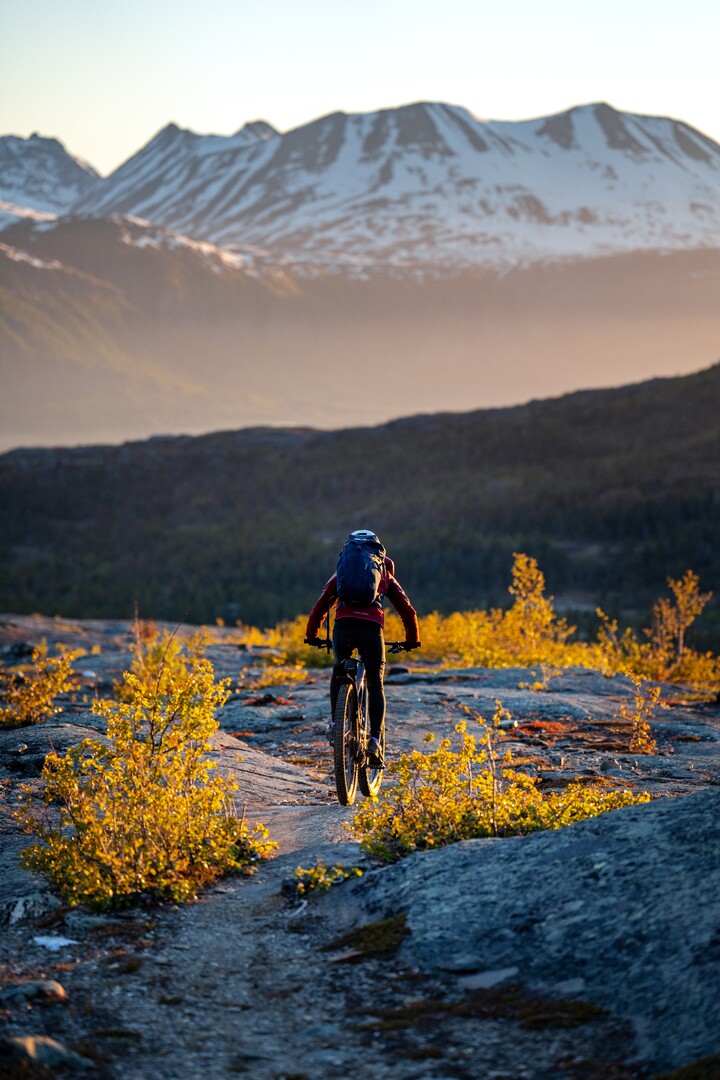
A DNT Red ridge climb on the non-glaciated side of the Lyngen peninsula. 900 metres of gain, a steep final ridge with exposure, and a summit view straight across the Lyngenfjord.
Rørnestinden is 992 metres, directly above the Kjosen valley in the Lyngen Alps. 8 km round trip, 900 m of gain, 5 to 6 hours. DNT Red with an exposed final ridge. Non-glaciated, so no rope team, but this is an alpine day with serious turn-back conditions.
Rørnestinden is one of the non-glaciated peaks that built Lyngen's reputation with intermediate ski tourers and summer ridge hikers. At 992 metres it is not the highest in the range, but the final 200-metre ridge is exposed, the approach is steep, and the summit looks straight across the Lyngenfjord at the big glaciated faces on the other side. It is a full alpine day without the glacier gear requirement.
This is DNT Red. It is not Besseggen Red. The scrambling is shorter but the ridge has real consequence. If you have not spent time on exposed ridges before, do Store Kjostind's southwest flank first and build up.
The honest grade
Rørnestinden is DNT Red: strenuous, with scrambling and exposure. In summer it is a hands-on ridge, not a hike. The ridge itself is narrow in places. There are no fixed chains, no marked bolts. If cloud closes on the ridge, navigation gets difficult fast because the sides drop steeply on both flanks.
In ski-touring season, Rørnestinden is a committing objective. The approach slope from the Kjosen valley is 35 to 40 degrees in places. This is avalanche terrain. Bring a transceiver, shovel, and probe, and know how to use them under pressure. Avalanche Level 2 skills are the baseline for anyone touring here unguided.
The route (summer)
Trailhead. Park at the small gravel area signed for Rørnestinden on the E6 between Oteren and Skibotn at the mouth of the Kjosen valley. Look for the marked path. Limited parking, 8 to 10 cars.
Lower section. The trail climbs steeply through birch forest for 300 metres of gain, then emerges above the tree line onto open tundra. 60 to 80 minutes.
Middle section. Open slope climbing across scree and grass toward the summit ridge. Marker cairns visible in clear weather. Gradient increases steadily. 60 to 90 minutes.
Summit ridge. The final 200 metres of elevation gain happens on a narrow ridge with scrambling and exposure on both sides. Hands come out of pockets. Do not rush. The rock is generally solid granite with clear holds. 45 to 60 minutes.
The turn-back rule
- Cloud on the ridge. Navigation on the summit ridge in poor visibility is a different problem than in clear weather. If cloud is down to 800 metres, turn back at the sub-summit.
- Wind above 15 m/s. The ridge is too narrow to be safe at that wind speed. Descend.
- Wet rock on the ridge. The scrambling sections are slippery when wet. Allow rock to dry before committing to the upper ridge.
- Rising snow-line in late season. Fresh snow on the summer ridge changes the route to winter conditions. Reverse.
Gear for this route (summer)
- Alpine hiking boots with stiff sole. Trail runners are wrong for this ridge.
- Wind shell, insulation layer, spare gloves. The summit is 1,000 metres above sea level and windy.
- Helmet. Not ironic. Loose rock can be kicked down from above on the popular section.
- Map, compass, and GPS. Summit ridge in cloud is not a phone-only problem.
- Water (2 litres). No reliable source above 400 metres.
- First aid kit. A sprained ankle 3 kilometres out and 900 metres up is a long rescue.
Fjellvettreglene on this route
Four rules of the Norwegian Mountain Code are directly load-bearing on Rørnestinden:
- Rule 2: Adapt the trip to ability and conditions. DNT Red is the grade. Fitness and scrambling experience are baseline.
- Rule 3: Pay attention to weather and avalanche forecasts. In ski season, this route is avalanche terrain. Check varsom.no the night before and the morning of.
- Rule 7: Use a map and compass. Phone-only navigation is not enough on the summit ridge in cloud.
- Rule 8: Turn back in time. The ridge is where the turnarounds happen. Do it.
The logistics
| Detail | Information |
|---|---|
| Summit elevation | 992 m |
| Distance | 8 km round trip |
| Elevation gain | 900 m |
| Time | 5 to 6 hours round trip |
| DNT grade | Red (strenuous, exposed ridge) |
| Season | July to September (summer). Ski touring February to May. |
| Trailhead | E6 at the Kjosen valley, between Oteren and Skibotn |
| Parking | Gravel lay-by, 8 to 10 cars, free |
| Trailhead GPS | 69.4390°N, 20.1770°E |
| Mobile coverage | Patchy above 600 metres |
| Emergency | 112 (police/rescue), 113 (medical) |
Who should hike this
- Experienced ridge walkers. If you have done Hurrungane, Romsdalseggen, or similar, this is within your range.
- Ski tourers in spring looking for a harder objective. The south and east aspects give a long ski descent in the right conditions.
- Photographers wanting the view back at the glaciated peaks. Rørnestinden looks straight at Store Kjostind, Tafeltinden, and the Jiehkkevárri massif.
Who should skip this
- Anyone without scrambling experience. The summit ridge is not optional. There is no bypass.
- Travellers in poor weather. This is not a route to force. Wait a day.
- First-time visitors to Lyngen in summer. Do Store Kjostind's southwest flank first. Build up.
Marte Åsheim is the Mountain Safety Editor at NorgeTravel. DNT-certified guide with 18 years of experience across Jotunheimen, Rondane, and the Nordic peaks. She writes trail guides so that you come home afterward. She can be reached at hei@norgetravel.com.
Image: Lyngen Alps ridge view by Petr Pavlíček, provided by Visit Lyngenfjord.
Plan your Norway itinerary
Use our free, interactive trip planner to map out your route through Norway, book verified eco-friendly cabins and transport, and sync with local ferry timetables.
Up Next: Keep Exploring
RIB Fjordsafari Geirangerfjord: what the cruise ship cannot show you
The RIB Fjordsafari puts you 15 meters from the Seven Sisters waterfall at 35 knots. Here is exactly what works, what does not, and whether the 895 NOK price tag is justified.
Kayaking beneath the Seven Sisters: 4 hours on Geirangerfjord at paddle height
The Geiranger kayak tour puts 8 paddlers beneath the Seven Sisters waterfall at arm's reach from the cliff wall. 4 hours, 1,550 NOK, drysuits provided. Here is exactly what the experience delivers and who should book it.
Geiranger by car: Eagle Road, Flydalsjuvet, and Dalsnibba in one drive
The Eagle Road climbs 620 meters in 11 hairpin bends. Dalsnibba sits at 1,476 meters with the fjord as a thin blue line below. Here is how to drive both in a single day without fighting the tour buses for parking.