スタールハイムからノーリ 2026年:ネーロイダーレン渓谷を見下ろす標高500mの絶景ポイント、DNTブルーグレードの片道2.8kmのトレイル
スタールヘイムスクレイヴァの上、スタールハイム・ホテルから始まるこのトレイルは、古い農地を抜けて250m登り、ノーリ展望台へと続きます。展望台からは、ネーロイダーレン渓谷をグドヴァンゲン方面へまっすぐ見下ろす絶景が広がります。片道2.8km、DNTブルーグレード、往復2~4時間の行程です。
スタールハイムからノーリへのトレイルは、スタールヘイムスクレイヴァ道路の上にある歴史あるスタールハイム・ホテルから始まり、海抜約500メートルのノーリ展望台へと登ります。片道2.8km、標高差は250mから260mで、DNTブルーグレードに指定されています。展望台からはネーロイダーレン渓谷をグドヴァンゲン方面へ見下ろす絶景が広がります。注意:バッカからノーリへのルートは公式なトレイルではありません。正しいルートはスタールハイムから出発します。
First, the naming. You will find references online to a "Bakka–Nåli" trail on Nærøyfjord. The trail does not exist under that name. Bakka is a village on the western shore of Nærøyfjord. Nåli is a viewpoint above Stalheim, on the ridge at the head of the Nærøydalen valley. They sit on opposite sides of different bodies of water and are not connected by a marked trail. The route that is real, marked, and published on ut.no is the Stalheim–Nåli trail. That is the trail this guide covers.
Stalheim to Nåli is the short, steady climb from the historic Stalheim Hotel above Stalheimskleiva to a viewpoint at roughly 500 metres above sea level with a clean sightline down the Nærøydalen valley. 2.8 km each way, 250 to 260 metres of elevation gain, DNT Blue, and 2 to 4 hours round trip at a walking pace. It is one of the most accessible viewpoint hikes in the Sognefjord hinterland and one of the quietest.
What this trail actually is
The Stalheim–Nåli path leaves from behind the Stalheim Hotel and climbs the slope above the hotel grounds to the Nåli viewpoint. The trail is marked by the local hiking authority and shown on ut.no. The grade is DNT Blue: moderate effort, distances under 10 km, elevation gain under 600 metres, and no technical scrambling.
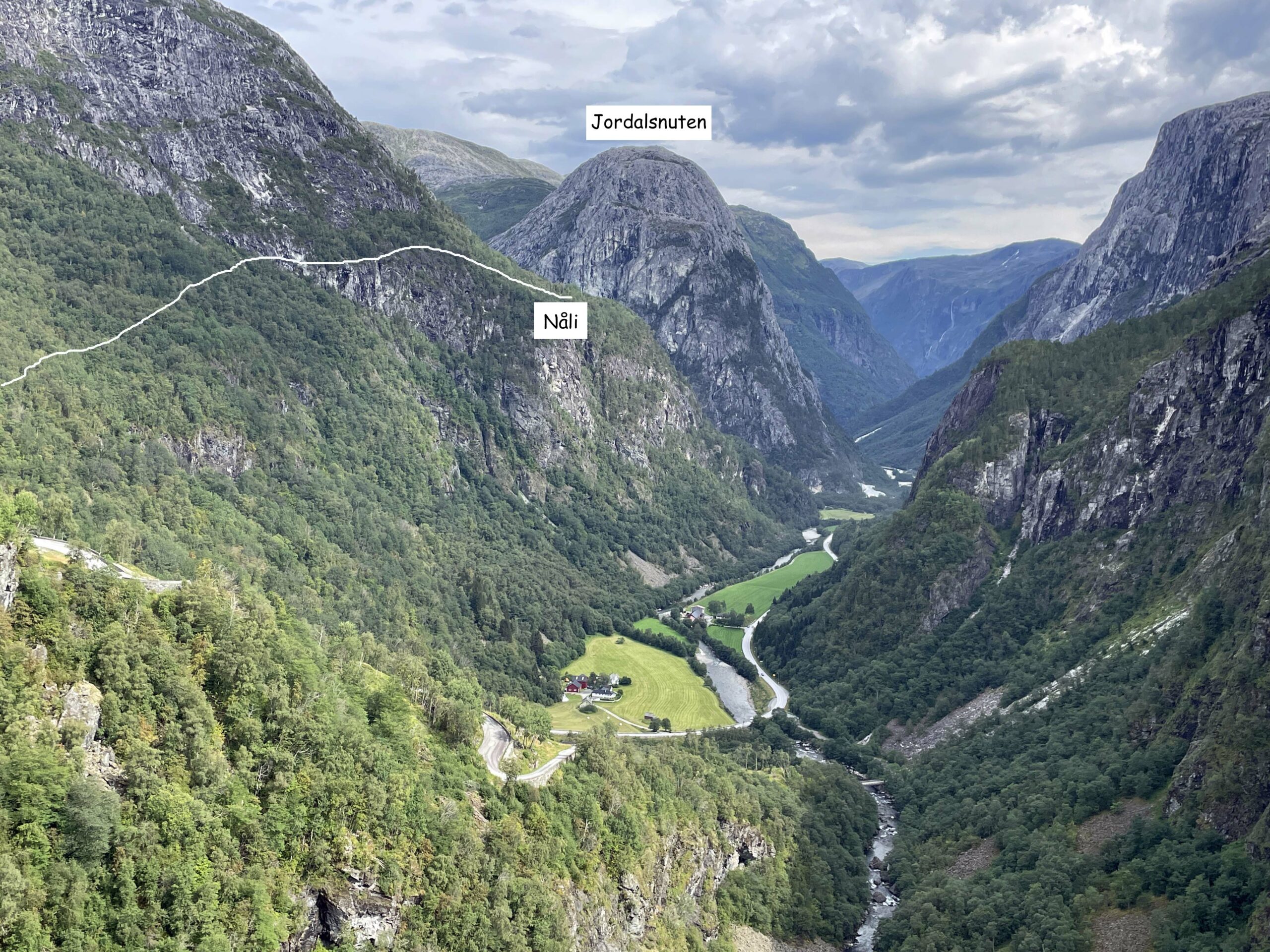
The route runs through mixed forest and old grazing land. You gain elevation steadily rather than in steep pulses. The final approach opens out of the trees with the Nærøydalen valley stretching below you. On a clear day, the valley floor is visible all the way down toward Gudvangen.
Time: approximately 1 to 2 hours up, 1 to 1.5 hours down. Budget 2 to 4 hours for the round trip including time at the viewpoint.
What you see from Nåli
The viewpoint looks down the Nærøydalen valley, not at Nærøyfjord itself. Nærøydalen is the green, glacially carved valley that drops from Stalheim toward Gudvangen, flanked on both sides by cliff walls that rise 900 to 1,000 metres from the valley floor. The Nærøyelva river runs along the valley floor. The Stalheimskleiva road switchbacks visibly below the hotel.
Nærøyfjord proper begins at Gudvangen, several kilometres down the valley. You do not see the fjord water from Nåli. You see the landscape that leads into it, which is arguably the more complete Nærøy view: the glacial geology that created the narrowest UNESCO fjord in Europe, framed in a single sightline.
What works
- The grade. DNT Blue means this hike is accessible to most travellers with reasonable fitness. No scrambling, no exposure. 250 metres of elevation on a marked path is a normal afternoon walk, not an expedition.
- The trailhead access. The Stalheim Hotel sits directly on the E16 above the Stalheimskleiva, with parking on site. If you are driving between Voss and Gudvangen, the trailhead is a 2-minute detour.
- The valley perspective. The view down Nærøydalen toward Gudvangen shows the landscape that the Norway in a Nutshell ferry passengers only see from sea level. The scale of the valley cliffs is different from above. This is the complement to the fjord cruise, not a replacement.
- The quiet. The Stalheim Hotel sees passing traffic but almost no one walks up to Nåli. You will likely have the viewpoint to yourself outside peak summer weekends.
What does not work
- Expecting a Nærøyfjord water view. There is no fjord water visible from Nåli. The view is of the valley that leads to the fjord. If you want water, book the Flåm to Gudvangen cruise.
- Winter access. Snow on the upper section of the trail closes it for casual walkers from November through April. Stalheimskleiva road is closed in winter. Come in May to October.
- No facilities on the trail. Stalheim Hotel has food, toilets, and water. The trail itself has none of the above. Bring water and a snack.
- Confusion with "Bakka–Nåli." This is not a trail. If you are using a guide that claims a Bakka to Nåli route with an 800-metre climb from the fjord shore, the guide is wrong. The correct trail starts at Stalheim.
The logistics
| Detail | Information |
|---|---|
| Trail name | Stalheim to Nåli (marked on ut.no) |
| Distance | 2.8 km each way, 5.6 km round trip |
| Elevation gain | 250 to 260 m |
| Viewpoint elevation | Approximately 500 m above sea level |
| Time | 2 to 4 hours round trip |
| Grade | DNT Blue (moderate) |
| Season | May to October |
| Trail fee | Free |
| Trailhead | Stalheim Hotel, above Stalheimskleiva, E16 between Voss and Gudvangen |
| Parking | Stalheim Hotel car park |
| Facilities | At Stalheim Hotel. None on trail. |
| Navigation | Download ut.no route offline before starting |
| Emergency | 112 police and rescue, 113 medical |
Trail safety
Stalheim to Nåli is DNT Blue and does not carry the exposure or technical risk of the Red-graded fjord trails. Three Fjellvettreglene rules still apply:
- Rule 1: Plan and communicate your route. Tell reception at Stalheim Hotel or your accommodation that you are walking to Nåli. Download the ut.no route offline before you leave mobile coverage.
- Rule 2: Adapt the trip to ability and conditions. 250 metres of elevation in 2.8 km is a moderate walking grade. Hiking shoes rather than trainers. A rain shell. Water.
- Rule 3: Pay attention to weather and avalanche forecasts. Check yr.no for Stalheim before you start. The viewpoint has no shelter. In heavy rain or wind, the forested lower section is workable but the exposed upper ridge is not.
Who should hike this
- Travellers with a spare afternoon in the Voss to Gudvangen corridor. If you are driving between Bergen and Flåm on the E16, Stalheim to Nåli adds 3 to 4 hours and gives you the valley view that the road only hints at.
- Families with older children (10+). The grade is manageable and the viewpoint is a genuine reward. This works as a first Norwegian hike for visitors with moderate fitness.
- Travellers doing Norway in a Nutshell who have an extra day. The cruise shows you Nærøyfjord from the water. Nåli shows you the valley that leads to it from 500 metres above.
Who should skip this
- Visitors between November and April. Trail and road conditions do not support casual hiking. Come back in May.
- Anyone expecting a view of Nærøyfjord water. The fjord is not visible from Nåli. If the water view is what you want, the Prest summit above Aurland is the better choice, or book the Flåm to Gudvangen cruise.
- Travellers with under 3 hours to spare. The round trip is 2 to 4 hours depending on pace and time at the viewpoint. A 60-minute tourist stop does not cover it.
Ingrid Solheim is the Fjord Logistics Editor at NorgeTravel. She spent eleven years putting tourists into rental cars in Bergen and watching them drive off with itineraries that were never going to work. Her guides are written so that does not happen to you. She can be reached at hei@norgetravel.com.
ノルウェー旅行のプランを立てる
無料のインタラクティブなトリッププランナーで、ノルウェーのルートを計画し、認証済みのエコフレンドリーな宿泊と交通を予約し、現地のフェリー時刻表を確認できます。
Up Next: Keep Exploring
RIBフィヨルドサファリ ゲーランゲルフィヨルド:クルーズ船では味わえない体験
RIBフィヨルドサファリなら、セブンシスターズの滝からわずか15メートルの距離まで時速35ノットで大接近。このツアーの魅力、惜しい点、そして895ノルウェークローネという料金が本当に妥当なのかを正直にレビューします。
セブンシスターズの滝の下でカヤック体験:ガイランゲルフィヨルドをパドルで4時間
ガイランゲルでのカヤックツアーでは、8名のパドラーがセブンシスターズの滝のすぐ下、切り立った崖の壁に手が届くほどの距離に。4時間、1,550ノルウェークローネ、ドライスーツ貸与。この体験で得られるものと、どんな人におすすめなのかを詳しくご紹介します。
車で巡るガイランゲル:鷲の道、フライダルスユーヴェ、ダルスニッバを一日で満喫
鷲の道は11のヘアピンカーブで620メートルの高さを駆け上がり、ダルスニッバ(標高1,476メートル)からはフィヨルドが細い青い線となって眼下に広がります。ツアーバスと駐車スペースを奪い合うことなく、これらすべてを一日でドライブする方法をご紹介します。