フェストヴォーグティン:ヘニングスヴァーを見下ろす標高541mの峰
頂上付近にスクランブルがある短く急峻なDNTブルーのコースで、ヘニングスヴァーの島々を望む最高の景色が楽しめます。全長3km、標高差500m、脚力に自信のある方なら約2時間で踏破可能です。
フェストヴォーグティンはアウストヴォーゴヤ島のヘニングスヴァーの真上にそびえる標高541mの山です。往復3km、標高差500m、所要時間2~3時間。頂上付近に短いスクランブルがあるDNTブルーのコースです。登山口はヘニングスヴァー橋手前のRv816号線沿い。レーヌブリンゲンに代わる、より静かな選択肢としても知られています。
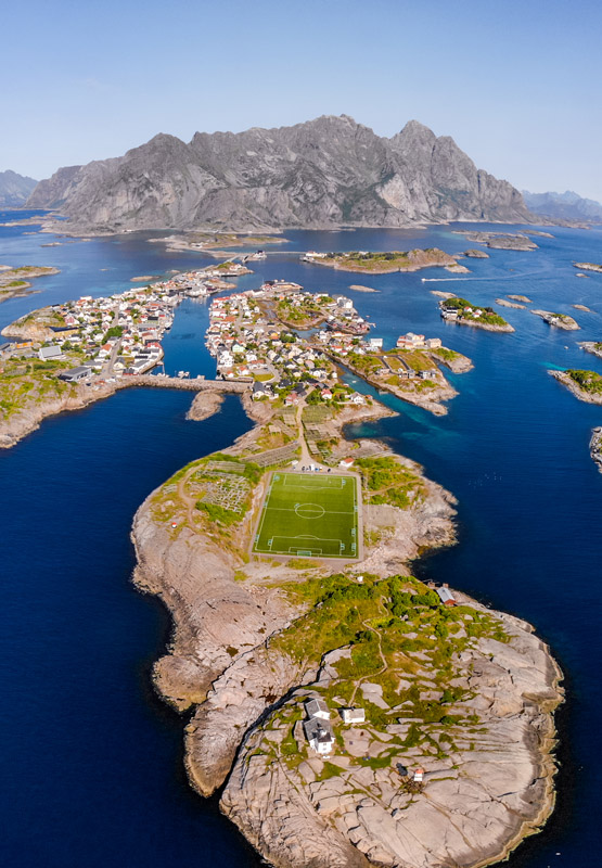
The football pitch photo of Henningsvær, the one that shows the pitch on a rock in the middle of the sea with a mountain behind it, is taken from Festvågtind. The mountain is 541 metres high, the trail to the top is 1.5 kilometres each way, and you can be on the summit two hours after you leave your car. The reason more visitors do not do this hike is that Reinebringen is more famous. That is also the reason to do this one.
Festvågtind is DNT Blue with a short summit scramble. It gains 500 metres over 1.5 km ascending, averaging 33 per cent gradient. The path is marked, mostly on rock and short grass, with a genuine but short scramble in the last 50 metres to the summit. Most hikers complete the round trip in 2 to 3 hours. Fit groups in 90 minutes.
The honest grade
Festvågtind is DNT Blue: medium difficulty, elevation under 600 metres, distance under 10 km. The upper summit scramble is short enough that it does not push the route to Red, but it is real. Hands come out of pockets for the last 50 metres. The rock is generally dry, solid granite with clear holds. No chains, no fixed ropes, no exposure to major drops below the ridge line.
The gradient is the main test. 500 metres of gain in 1.5 km is as steep as Reinebringen on average, but without the stone staircase. The surface is a mix of rock slabs, short grass, and a rough-engineered boot-stamp path. Waterproof boots with grip are the right choice. Trail runners work in dry conditions.
The summit has a narrow rocky platform with a cairn. The drops on the west side (toward Henningsvær) are substantial but not exposed at the cairn itself. Stay back from the edge. People have been injured on similar exposed cairns across Norway by approaching the drop for a photograph.
The route
Trailhead. The marked path starts from a small gravel lay-by on the Rv816, approximately 2 kilometres north of Henningsvær, just before the first of the two bridges that connect the village to Austvågøya. Parking is limited: 10 to 15 spaces. In July and August it fills by 10:00. Do not park on the shoulder of the Rv816. The road is narrow and local residents will call tow trucks.
Lower section. The path climbs directly from the roadside through birch scrub and onto the first grass bench at around 200 metres. This section is steady, well-trodden, and unmistakable. 30 to 40 minutes.
Middle section. The grass bench gives way to exposed rock slabs with occasional scree. The gradient increases. Route markers (cairns and red paint) continue to the sub-summit ridge at around 480 metres. 30 to 40 minutes.
Summit scramble. The final 50 metres require hands-on movement over solid granite. No exposure to sheer drops in the standard line. Pick your holds deliberately. The cairn sits on a platform with views over Henningsvær, the Vestfjord, and on a clear day the Lofoten Wall from Austvågøya to Moskenesøya. 10 to 20 minutes.
The view
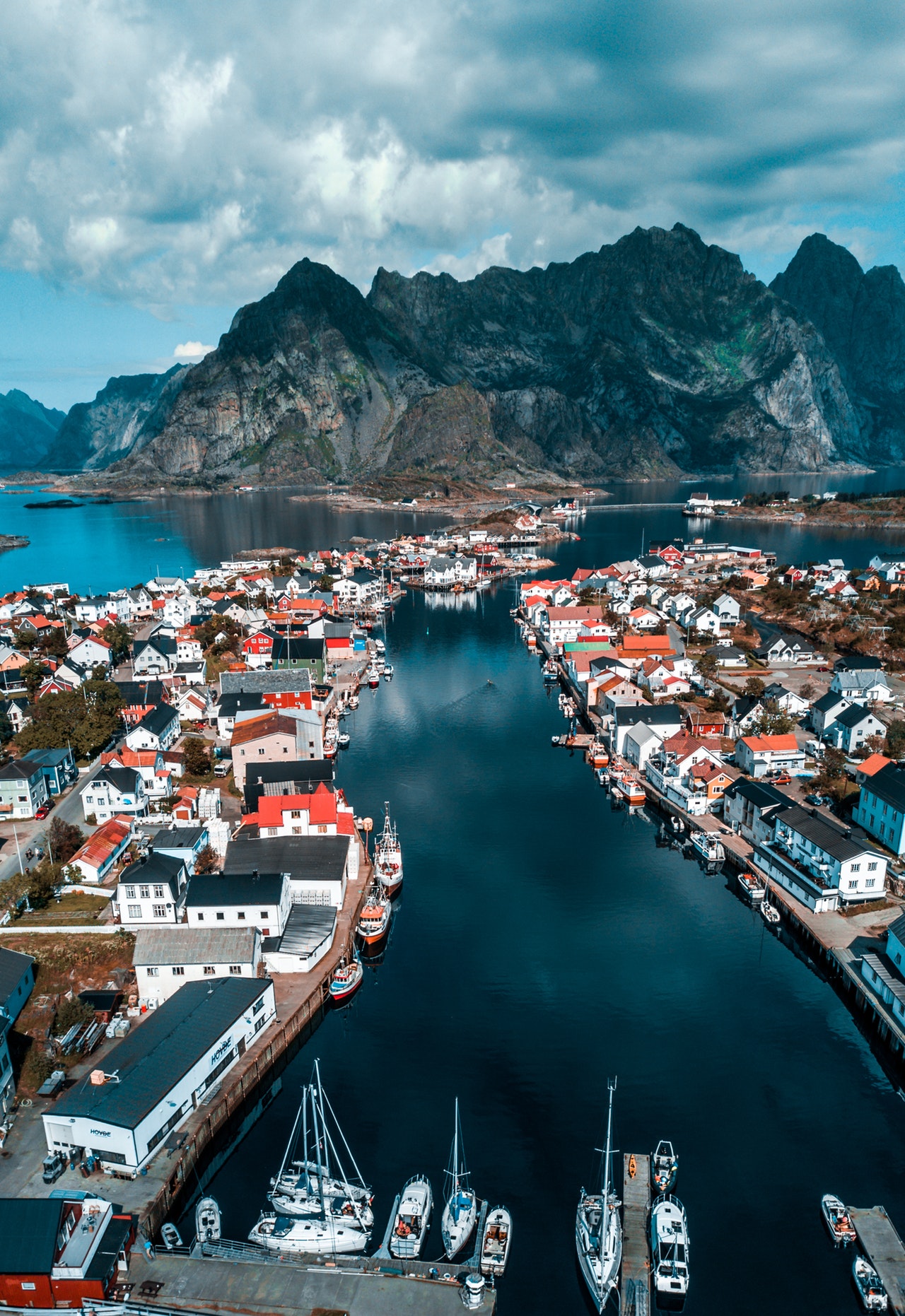
The summit of Festvågtind sits directly over Henningsvær. The perspective is different from every other Lofoten viewpoint. Most of them look at mountains from across the sea. This one looks down at islands and a working harbour from directly above. The football pitch, the fish-drying racks on Heimøya, the Svingen harbour boats, and the 10 inhabited islets of the village are all visible as a layout rather than a horizon.
On a clear day you can see as far as Austvågøya's east coast and the beginning of Vågakallen's ridge to the south. The light in July is consistent from mid-morning through early afternoon. The light in February is brief but extraordinary when it comes.
The turn-back rule
- Wet summit scramble. The upper 50 metres are more committing on wet rock. If the last rainfall was in the previous two hours, stop at the sub-summit ridge. The view from there is already good.
- Wind above 12 m/s. The summit platform is exposed. Not fatally so, but uncomfortable and unstable for photography.
- Ice or snow above 400 metres. The upper scramble without grip is a different problem than the summer version. Add microspikes or reroute to a lower hike.
Gear for this route
- Hiking boots with ankle support and grip. The mix of grass, slab, and scramble does not reward flexible trail runners in the wet.
- Wind shell jacket. The summit has no shelter.
- Water (1 to 1.5 litres). No water source on route.
- Snack for the summit. You will want to stay at the cairn longer than you expect.
- Charged phone. Mobile coverage is reliable across the route.
- Trekking poles are useful on the descent, particularly if rain made the grass slick.
Fjellvettreglene on this route
Three rules of the Norwegian Mountain Code are directly load-bearing on Festvågtind:
- Rule 2: Adapt the trip to ability and conditions. The DNT Blue grade assumes dry weather. Upgrade your gear thinking if the forecast shows rain.
- Rule 4: Be equipped to help yourself and others. Short as the route is, a slip on the summit scramble can mean broken bones. Basic first aid kit applies.
- Rule 8: Turn back in time. The summit scramble in wet rock is where the turnarounds happen. Do it.
The logistics
| Detail | Information |
|---|---|
| Summit elevation | 541 m |
| Distance | 3 km round trip |
| Elevation gain | 500 m |
| Time | 2 to 3 hours round trip |
| DNT grade | Blue (medium) with short summit scramble |
| Season | June through September. Snow above 400m in shoulder months. |
| Trailhead | Rv816, 2 km north of Henningsvær, before the first bridge |
| Parking | Small gravel lay-by, 10 to 15 spaces, free |
| Trailhead GPS | 68.1625°N, 14.1890°E |
| Mobile coverage | Available along entire route |
| Water on route | None. Carry 1 to 1.5 litres. |
| Emergency | 112 (police/rescue), 113 (medical) |
Who should hike this
- Travellers basing in Henningsvær. The trailhead is a 10-minute drive from the village. You can hike before breakfast and be back for coffee at Klatrekafeen.
- Hikers avoiding the Reinebringen queue. Same quality of summit experience, a genuinely different view, and substantially fewer people.
- Visitors with limited time in Lofoten. If you have one free morning and you are on Austvågøya, this is the route. Moskenesøya peaks require the full E10 drive.
Who should skip this
- Anyone uncomfortable with hands-on scrambling. The final 50 metres to the cairn require it. The sub-summit ridge is a good turn-around point with a partial view.
- Travellers in wet or icy conditions. The summit scramble in rain is a different hike. Wait for a dry window.
- Hikers with more than half a day. Festvågtind is a morning or an afternoon, not a full day. If you have longer, link it with a kayak paddle in the Henningsvær archipelago or the drive to Svolvær.
Marte Åsheim is the Mountain Safety Editor at NorgeTravel. DNT-certified guide with 18 years of experience across Jotunheimen, Rondane, and the Nordic peaks. She writes trail guides so that you come home afterward. She can be reached at hei@norgetravel.com.
Image: Henningsvær aerial by Tobias Bjørkli, provided by Visit Northern Norway.
ノルウェー旅行のプランを立てる
無料のインタラクティブなトリッププランナーで、ノルウェーのルートを計画し、認証済みのエコフレンドリーな宿泊と交通を予約し、現地のフェリー時刻表を確認できます。
Up Next: Keep Exploring
RIBフィヨルドサファリ ゲーランゲルフィヨルド:クルーズ船では味わえない体験
RIBフィヨルドサファリなら、セブンシスターズの滝からわずか15メートルの距離まで時速35ノットで大接近。このツアーの魅力、惜しい点、そして895ノルウェークローネという料金が本当に妥当なのかを正直にレビューします。
セブンシスターズの滝の下でカヤック体験:ガイランゲルフィヨルドをパドルで4時間
ガイランゲルでのカヤックツアーでは、8名のパドラーがセブンシスターズの滝のすぐ下、切り立った崖の壁に手が届くほどの距離に。4時間、1,550ノルウェークローネ、ドライスーツ貸与。この体験で得られるものと、どんな人におすすめなのかを詳しくご紹介します。
車で巡るガイランゲル:鷲の道、フライダルスユーヴェ、ダルスニッバを一日で満喫
鷲の道は11のヘアピンカーブで620メートルの高さを駆け上がり、ダルスニッバ(標高1,476メートル)からはフィヨルドが細い青い線となって眼下に広がります。ツアーバスと駐車スペースを奪い合うことなく、これらすべてを一日でドライブする方法をご紹介します。