ヘステン:セグラの向かいにある展望峰、センヤ島
メフィヨルド北側、標高556m。セグラのベストショットが撮れる場所。DNTブルー指定、往復7km、所要4時間。
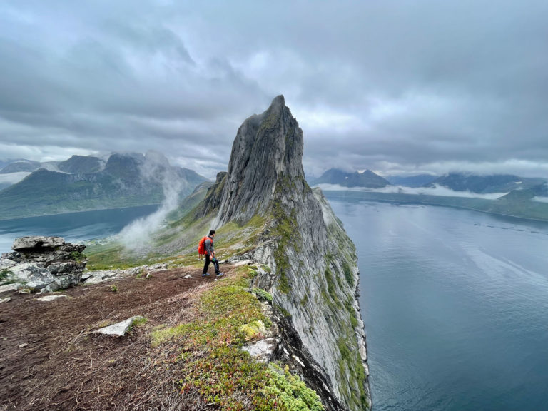
ヘステンは、セグラからメフィヨルドを挟んだ対岸に位置する標高556mの山。往復7km、所要4時間、DNTブルー指定。山頂からは、自身のケルンからセグラがフレームいっぱいに広がる、あの定番の絶景が楽しめます。
If your reason for being on Senja is to photograph Segla, you want to be on Hesten. From the Segla summit itself, Segla fills the frame you are standing on. From Hesten, across the Mefjord, Segla rises as the sharp blade of rock that built Senja's reputation. 556 metres, DNT Blue, 4 hours round trip on a good path.
This is the right hike if you are on a family trip, arrived too late to get a Segla car-park spot, or want the photograph rather than the summit.
The honest grade
DNT Blue. Marked T-path throughout. One short steep section in the middle third. No scrambling, no exposure on the summit. The summit is broad enough for a group to spread out and set up tripods.
The route
Trailhead. Fjordgård, the same village as Segla, but a different car park on the north side of the village. Signed for Hesten. Smaller car park than Segla, roughly 40 cars, fills later because the hike is less Instagrammed.
Lower section. Marked path climbing through birch forest and open slope. 300 metres of gain in 60 minutes.
Middle section. Steeper open slope with cairns. 200 metres of gain in 40 minutes.
Summit. Broad flat summit with a clear view across to Segla, the Mefjord below, and the open sea to the north. Allow 30 to 60 minutes on top if the light is right.
Descent. Same route. 1.5 hours.
Timing for photographs
The Segla face is east-facing from Hesten. In midsummer, morning light on Segla is 05:00 to 09:00. The midnight sun side-lights the ridge from the north between 22:00 and 01:00. Cloud on the Segla summit is a feature, not a problem — Segla in cloud with clear light on the ridge is the better photograph.
Gear
- Hiking boots.
- Windproof layer.
- Tripod if you are shooting. The summit is broad.
- Map: Turkart Senja 1:50,000.
Fjellvettreglene applied
Rule 1: plan and communicate your route. Rule 4: be equipped — even on a 4-hour hike, a windproof and a head torch in shoulder season are not optional.
Logistics
| Item | Detail |
|---|---|
| Trailhead | Fjordgård, Hesten car park (north side of village) |
| Parking | ~40 cars, fee |
| Season | Mid-June to mid-October |
| Nearest fuel | Botnhamn or Gryllefjord |
| Emergency | 112. Nearest A&E: Tromsø (UNN) |
Who should do Hesten
Photographers targeting Segla. Families who want a real peak without the scramble. Anyone arriving at Fjordgård after 09:00 in July, when the Segla car park is already full.
Who should skip it
If you have only one day and you are a strong hiker comfortable with exposure, do Segla. Come back another day for Hesten.
ノルウェー旅行のプランを立てる
無料のインタラクティブなトリッププランナーで、ノルウェーのルートを計画し、認証済みのエコフレンドリーな宿泊と交通を予約し、現地のフェリー時刻表を確認できます。
Up Next: Keep Exploring
RIBフィヨルドサファリ ゲーランゲルフィヨルド:クルーズ船では味わえない体験
RIBフィヨルドサファリなら、セブンシスターズの滝からわずか15メートルの距離まで時速35ノットで大接近。このツアーの魅力、惜しい点、そして895ノルウェークローネという料金が本当に妥当なのかを正直にレビューします。
セブンシスターズの滝の下でカヤック体験:ガイランゲルフィヨルドをパドルで4時間
ガイランゲルでのカヤックツアーでは、8名のパドラーがセブンシスターズの滝のすぐ下、切り立った崖の壁に手が届くほどの距離に。4時間、1,550ノルウェークローネ、ドライスーツ貸与。この体験で得られるものと、どんな人におすすめなのかを詳しくご紹介します。
車で巡るガイランゲル:鷲の道、フライダルスユーヴェ、ダルスニッバを一日で満喫
鷲の道は11のヘアピンカーブで620メートルの高さを駆け上がり、ダルスニッバ(標高1,476メートル)からはフィヨルドが細い青い線となって眼下に広がります。ツアーバスと駐車スペースを奪い合うことなく、これらすべてを一日でドライブする方法をご紹介します。