プレスト2026:アウルランズフィヨルドを見下ろす標高1,478mの山頂、ステーガスタインを過ぎたビョルガヴェゲン沿いの登山口
このトレイルは、アウルランから8km上流のビョルガヴェゲンから始まり、標高1,478mのプレスト山頂まで500mを登り、アウルランズフィヨルドを真下に見下ろします。片道2.1km、DNTレッド、6月中旬から10月上旬まで。
プレストのトレイルは、ビョルガヴェゲンの駐車場から標高1,478mのプレスト山頂を目指します。途中、1,363m地点のロイアグリンのビーコンが中間目標となります。片道2.1km、標高差500m、DNTレッド、往復2~3時間のコースです。急勾配で開けており、アウルランズフィヨルドを真下に望む絶景があなたを待っています。
The Prest trail is not the hike most visitors find when they search for "Flåm hiking." It does not leave from the railway terminus, the campsite, or the ferry pier. It leaves from a small parking bay on the Bjørgavegen, 8 km above Aurlandsvangen, past the Stegastein platform, on the mountain road that climbs the Aurlandsfjellet scenic route.
Most hikers who start this trail drove up from Aurland to photograph Stegastein first. Only a small fraction keep driving past the platform, look for the unmarked lay-by, and climb the 500 metres to the ridge above. That is why this trail stays quiet even in late July.
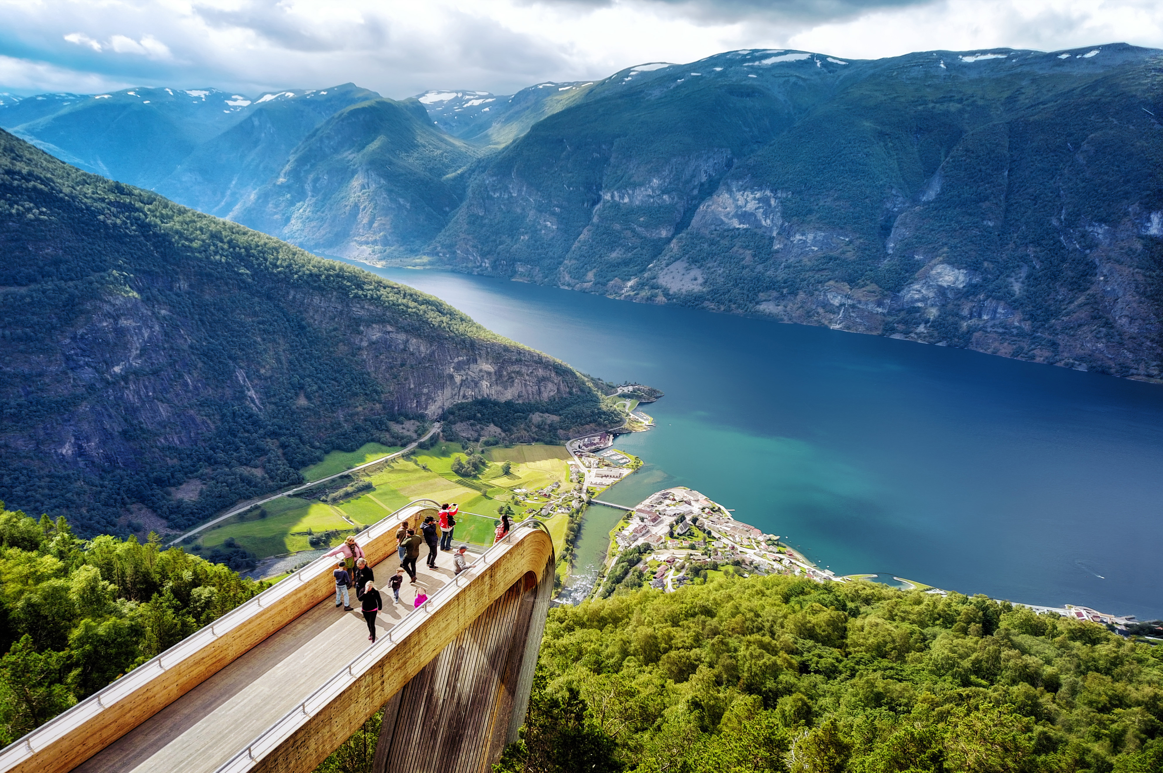
The trailhead
The Prest trailhead is a small unmarked parking bay on the Bjørgavegen (Fv243), approximately 8 km from Aurlandsvangen and past the Stegastein platform. From Stegastein, continue up the scenic route for roughly 2 km. The parking bay is on the right, with space for four or five cars. A faint path leaves the road and climbs directly up the slope.
There is no signposting at the trailhead. The Norwegian name of the trail is Prest, the summit is sometimes marked on maps as Prestholet. Download the ut.no app route offline before you leave mobile coverage in Aurland. The path is cairned once you are on the slope, but finding the start requires the app or local knowledge.
The route
The trail climbs steadily from the road at approximately 980 m to the Røyrgrind beacon at 1,363 m. This first section takes 1 to 1.5 hours and covers about 1.4 km of walking. The beacon is a stone cairn visible from some distance and is the natural turnaround point for hikers who do not want the full summit. The view from Røyrgrind is already substantial.
From Røyrgrind, the route continues across the high ridge to the Prest summit at 1,478 m. This section is approximately 700 m further and adds 115 m of elevation. It takes 30 to 45 minutes each way. The ridge is exposed. In strong wind or poor visibility, the intermediate beacon at Røyrgrind is the correct turnaround.
Total route: 2.1 km each way, 500 m elevation gain, 2 to 3 hours round trip including time at the summit. DNT grade: Red. The gradient is sustained (500 m in 2.1 km is roughly 24%), the terrain is rocky, and the final ridge is exposed without shelter.
The view
From the Prest summit, Aurlandsfjord sits almost vertically below you. The drop from 1,478 m to sea level is one of the steeper sightlines on any marked trail in the Sognefjord system. Aurland village is visible at the head of the fjord to the south. Flåm sits further south at the end of the Flåm arm. The Stegastein platform is visible below you to the east.
Nærøyfjord is not visible from Prest. The Nærøyfjord arm runs west from the fjord junction at Beitelen, behind the ridge that Prest sits on. Trail guides that claim a Nærøyfjord view from this summit are wrong. For Nærøyfjord from height, the Stalheim–Nåli route above Stalheim on the opposite side of the fjord network is the correct trail.
Season and conditions
The Bjørgavegen is a seasonal road. The scenic route opens in late May and closes in mid-October, weather dependent. Check vegvesen.no for current status before driving up. The Prest trail itself is snow-free from mid-June to early October in a typical year. Outside that window, the upper ridge holds snow and ice.
Weather at 1,478 m is not the weather in Aurland. Temperature at the summit runs 8 to 10°C cooler than the fjord floor. Wind on the exposed ridge is consistently stronger than forecast at the valley. Bring a windproof shell, a warm mid-layer, hiking boots with ankle support, and hands-free gloves for the final ridge in early or late season. Check yr.no for the Aurland forecast and add one category of severity for the summit.
Practical information
- Distance: 2.1 km each way, 4.2 km round trip
- Elevation gain: 500 m
- Summit elevation: Prest 1,478 m. Intermediate Røyrgrind beacon 1,363 m.
- Time: 2 to 3 hours round trip including summit time
- DNT grade: Red (demanding)
- Trailhead: Unmarked lay-by on the Bjørgavegen (Fv243), approximately 8 km from Aurlandsvangen, past Stegastein
- Season: Mid-June to early October. Bjørgavegen opens late May, closes mid-October.
- Navigation: Download ut.no offline. No signposting at trailhead.
- Facilities: None. Nearest toilets at Stegastein platform, 2 km back down the road.
- Emergency: 112 police and rescue, 113 medical
The Prest trail is the hike for travellers who already know they want effort over access. It is the answer to the question "I have seen Stegastein, what is the next level up?" The 500-metre climb and the ridge exposure mean this is not a casual afternoon. The view from the summit is the reason it is worth the drive past Stegastein and the walk from the lay-by.
Ingrid Solheim is the Fjord Logistics Editor at NorgeTravel. She spent eleven years putting tourists into rental cars in Bergen and watching them drive off with itineraries that were never going to work. Her guides are written so that does not happen to you. She can be reached at hei@norgetravel.com.
ノルウェー旅行のプランを立てる
無料のインタラクティブなトリッププランナーで、ノルウェーのルートを計画し、認証済みのエコフレンドリーな宿泊と交通を予約し、現地のフェリー時刻表を確認できます。
Up Next: Keep Exploring
RIBフィヨルドサファリ ゲーランゲルフィヨルド:クルーズ船では味わえない体験
RIBフィヨルドサファリなら、セブンシスターズの滝からわずか15メートルの距離まで時速35ノットで大接近。このツアーの魅力、惜しい点、そして895ノルウェークローネという料金が本当に妥当なのかを正直にレビューします。
セブンシスターズの滝の下でカヤック体験:ガイランゲルフィヨルドをパドルで4時間
ガイランゲルでのカヤックツアーでは、8名のパドラーがセブンシスターズの滝のすぐ下、切り立った崖の壁に手が届くほどの距離に。4時間、1,550ノルウェークローネ、ドライスーツ貸与。この体験で得られるものと、どんな人におすすめなのかを詳しくご紹介します。
車で巡るガイランゲル:鷲の道、フライダルスユーヴェ、ダルスニッバを一日で満喫
鷲の道は11のヘアピンカーブで620メートルの高さを駆け上がり、ダルスニッバ(標高1,476メートル)からはフィヨルドが細い青い線となって眼下に広がります。ツアーバスと駐車スペースを奪い合うことなく、これらすべてを一日でドライブする方法をご紹介します。