トロムスダルスティンデン:トロムソを見守る標高1,238mの山頂
トロムソの街のどの窓からも見える三角形の頂は、DNTレッドに指定された丸一日がかりのアルパインハイキングです。距離18km、獲得標高1,100m、所要時間8~10時間、夏期限定。
トロムスダルスティンデン(現地では「トロムスダルスティンド」)は、標高1,238mでトロムソのスカイラインを象徴する山頂です。トヴェレルブダーレンからの標準ルートは、岩場や急峻な頂上ブロックを越える往復18kmのコース。DNTレッドに分類され、夏期限定。初めての北極圏ハイキングには不向きです。
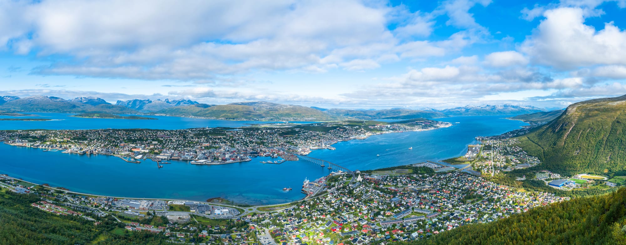
Every photograph of Tromsø has one detail in common: a triangular peak rising behind the city from the east. That peak is Tromsdalstinden, known locally as Tromsdalstind or simply Tinden. It is 1,238 meters high, it is visible from every street in the city centre on a clear day, and it is the mountain every experienced Tromsø hiker points to when asked for a serious day out.
I have walked this trail roughly thirty times over twenty-five years of guiding in Troms. Half of those ascents ended at the summit. The rest turned back in cloud, wind, or the wrong kind of snow. This is not a trail you complete on every attempt. It is a trail where turning back is often the correct decision, and the locals respect the mountain enough to know that.
What this trail actually is
Tromsdalstinden is a DNT Red alpine hike with the standard route starting at the Tverrelvdalen parking area, approximately 30 minutes' drive east of Tromsø city centre. The trail runs through birch forest for the first 3 km, breaks above the treeline around 400m, and then ascends a broad open slope of heather, rock, and scree toward the summit ridge.
From the end of the approach valley at roughly 700m, the climb steepens. The upper 500m is a mixture of large boulders, patches of permanent snow (even in August), and a defined summit block that requires scrambling on the final 150m. There is no technical climbing gear required, but there is no marked trail above 900m. Route-finding across the boulder field becomes the main challenge when visibility drops.
Round trip is approximately 18 km. Elevation gain is 1,100 meters from the trailhead to the summit. Time on foot is 8 to 10 hours for a typical fit hiker. Experienced parties move faster. Tired parties take longer. Plan for a full day.
Two approaches, neither easy
Standard route from Tverrelvdalen (south). Park at the Tverrelvdalen road end. Follow the marked trail along the valley for 5 km, cross the river on the footbridge, and climb the south slope to the summit ridge. This is the most-used route and the one described in local guidebooks. 18 km round trip, 8–10 hours.
Northern route from Breivikeidet. A longer approach from the Breivikeidet valley north of the mountain. More wilderness character, less traffic, steeper summit approach. 22 km round trip, 10–12 hours. Recommended only for parties comfortable with off-trail navigation in alpine terrain.
Most people combine the ascent with an overnight at Skarvassbu DNT cabin (self-service, 15 bunks) if they are doing the northern route or making a two-day trip. The cabin sits at roughly 800m and requires a DNT membership to access the key system.
What works
- The view from the top. On a clear summit day, Tromsdalstinden gives you the full panorama of Troms and beyond: the Lyngen Alps to the east, the Vesterålen islands to the west, and Tromsø laid out below with the bridge visible between the city island and the mainland. On the clearest days, the horizon reaches 180 km. This is the landscape photograph that justifies the ten hours.
- The wilderness character. Tromsdalstinden is inside the city limits of Tromsø, but the upper half of the mountain feels remote. Between the treeline and the summit, you may not see another party. The trail is well-known but not overrun. Even on a peak July Saturday, count 20 to 30 summit attempts, not 200.
- The season window. The reliable hiking window is late June through mid-September. July and August are the months when the summit block is typically clear of winter snow. Early October sometimes gives the crispest summit days of the year, with the first dustings of new snow on the upper mountain and clearer air than July.
What does not work
- The weather. Tromsdalstinden is exposed on three sides and catches every front that crosses from the Norwegian Sea. A clear valley morning can turn to summit whiteout in two hours. The Norwegian Meteorological Institute runs a dedicated forecast for peaks in Troms at yr.no — check the 1,200m level, not the Tromsø city forecast. Two of my three turned-back attempts over twenty years were due to weather arriving faster than predicted.
- The boulder field. The upper 500m is not a trail. It is a boulder field with cairns placed every 30 to 50 meters on the most-used line. In cloud, the cairns disappear. A GPS track saved on your phone is essential — a printed 1:50,000 topo map is better. Compass bearings from known waypoints are the backup.
- The descent. The boulder field is harder on the descent than the ascent. Loose rock moves unexpectedly. The 1,100m elevation loss takes 4 to 5 hours on tired legs. Trekking poles are not optional for most parties; they are the difference between a manageable descent and an injured one.
- Summer snow. Snow patches persist on the northern aspects of the summit ridge into early August in most years. They are not avalanche-relevant in high summer, but they are slippery, and a slide on the wrong patch ends in rock at the bottom. Microspikes in the pack are sensible equipment for any ascent before mid-July.
The honest assessment
Tromsdalstinden is the serious day hike of the Tromsø area. It is the mountain local hikers climb once a year to check their fitness. It is not a first Arctic hike, and it is not a substitute for an organized summit trip. I see five or six underprepared attempts per season: visitors in city boots, without a shell layer, without a GPS, attempting the summit in cloud. Most of them turn back before the boulder field. The ones who don't are the ones who keep the local Røde Kors Hjelpekorps busy.
For fit hikers with alpine experience, proper gear, and a clear weather window, it is one of the best summit days in Nord-Norge. For anyone else — including most Tromsø visitors — the Sherpa Stairs to Fløya offers a mountain summit without the full commitment.
The logistics
| Detail | Information |
|---|---|
| Summit elevation | 1,238 m |
| Standard trailhead | Tverrelvdalen road end, 30 min drive from Tromsø centre |
| Round trip distance | ~18 km |
| Elevation gain | ~1,100 m |
| Time on foot | 8–10 hours fit, 10–12 hours moderate |
| DNT grade | Red (strenuous alpine). Scrambling on the final 150 m |
| Season | Late June to mid-September |
| Trail fee | Free |
| Parking (Tverrelvdalen) | Free, limited to ~15 cars |
| Nearest DNT cabin | Skarvassbu (self-service, 15 bunks, key from DNT Tromsø) |
| Mobile coverage | Intermittent above 800 m |
| Summit GPS | 69.6408°N, 19.2500°E |
| Emergency | 112 (rescue). Local SAR: Tromsø Røde Kors Hjelpekorps |
Required equipment
Non-negotiable items for a summit attempt:
- Hiking boots with ankle support and grip (not trail runners)
- Hardshell jacket and overtrousers — the summit is exposed and the weather changes fast
- Insulating layer: fleece or synthetic, plus hat and gloves even in July
- 1:50,000 topo map of the Tromsdalen area plus compass, with a GPS track as backup (not as primary)
- Headlamp with spare batteries
- 2 liters of water minimum, plus food for 10 hours
- First aid kit, emergency bivvy, whistle
- Trekking poles (not optional for most parties)
- Microspikes if hiking before mid-July
Fjellvettreglene (applied)
All nine Mountain Code rules apply to Tromsdalstinden, but five are specifically load-bearing on this trail:
- Rule 1: Plan your trip and communicate. Tell someone your route and expected return time. The standard route is long enough that phone battery can fail before you are back in coverage.
- Rule 2: Adapt the trip to ability. DNT Red means strenuous alpine. If you have never done 1,000m of gain in a day on alpine terrain, build up on smaller mountains first. Rødtinden on Kvaløya (644m, Blue) is a good test.
- Rule 3: Pay attention to weather. Forecasts for Tromsdalstinden come in layers: city forecast (unreliable for the summit), 1,000m forecast (directly relevant), and cloud-base prediction. Abort the summit if the cloud base is below 900m.
- Rule 7: Use a map and compass. Your phone is a secondary tool. The summit block in cloud has disoriented experienced hikers. GPS coordinates of the summit and the start of the boulder field should be written on paper as well as on the device.
- Rule 8: Turn back in time. The summit will be there next year. On 30 ascents I have turned back on 15. Nobody regrets a safe descent. A forced overnight on the mountain is a rescue event.
Who should hike this
- Fit hikers with alpine experience, proper equipment, and a full day
- Visitors spending a week or more in Tromsø during the July–August window, willing to wait for weather
- Trail runners and mountaineers using Tromsø as a summer basecamp
Who should skip this
- First-time Arctic visitors without alpine hiking experience
- Anyone without proper boots, shell layer, or navigation
- Cruise ship passengers or anyone on a tight schedule
- Winter visitors: this is a summer trail. The winter ski ascent is for experienced ski-mountaineers with avalanche training only
Bjørn Haugen is the Arctic Field Editor at NorgeTravel. DNT-certified guide (25+ years), Tromsø Røde Kors Hjelpekorps alumnus. He can be reached at hei@norgetravel.com.
Source data: DNT Tromsø trail database; Norges geologiske undersøkelse (NGU) topographic survey; Norwegian Meteorological Institute (yr.no) summit forecast archive; Tromsø Røde Kors Hjelpekorps incident reports 2019–2024.
ノルウェー旅行のプランを立てる
無料のインタラクティブなトリッププランナーで、ノルウェーのルートを計画し、認証済みのエコフレンドリーな宿泊と交通を予約し、現地のフェリー時刻表を確認できます。
Up Next: Keep Exploring
RIBフィヨルドサファリ ゲーランゲルフィヨルド:クルーズ船では味わえない体験
RIBフィヨルドサファリなら、セブンシスターズの滝からわずか15メートルの距離まで時速35ノットで大接近。このツアーの魅力、惜しい点、そして895ノルウェークローネという料金が本当に妥当なのかを正直にレビューします。
セブンシスターズの滝の下でカヤック体験:ガイランゲルフィヨルドをパドルで4時間
ガイランゲルでのカヤックツアーでは、8名のパドラーがセブンシスターズの滝のすぐ下、切り立った崖の壁に手が届くほどの距離に。4時間、1,550ノルウェークローネ、ドライスーツ貸与。この体験で得られるものと、どんな人におすすめなのかを詳しくご紹介します。
車で巡るガイランゲル:鷲の道、フライダルスユーヴェ、ダルスニッバを一日で満喫
鷲の道は11のヘアピンカーブで620メートルの高さを駆け上がり、ダルスニッバ(標高1,476メートル)からはフィヨルドが細い青い線となって眼下に広がります。ツアーバスと駐車スペースを奪い合うことなく、これらすべてを一日でドライブする方法をご紹介します。