史塔尔海姆至纳利 2026:纳柔依谷上方500米观景点,DNT蓝色标识,单程2.8公里
此小径始于史塔尔海姆酒店,位于史塔尔海姆峡谷上方,爬升250米穿过古老的农田,抵达纳利观景点,可俯瞰纳柔依谷,直达古德旺恩。单程2.8公里,DNT蓝色标识,往返2至4小时。
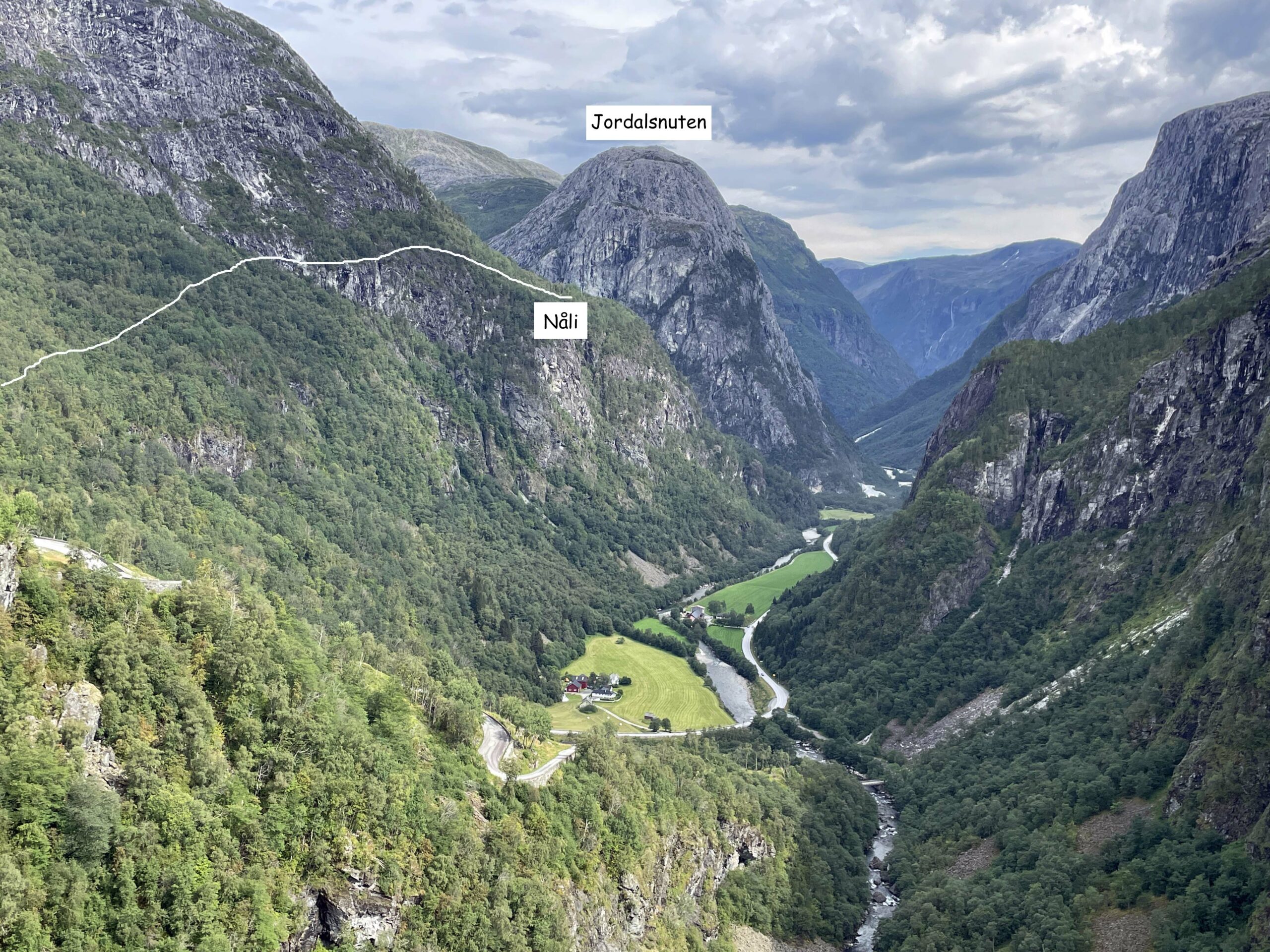
史塔尔海姆至纳利小径从历史悠久的史塔尔海姆酒店(位于史塔尔海姆峡谷公路上方)向上爬升,抵达海拔约500米的纳利观景点。单程2.8公里,海拔爬升250至260米,DNT蓝色等级。在此可俯瞰纳柔依谷,远眺古德旺恩。请注意:巴卡至纳利并非公认的小径。正确的路线始于史塔尔海姆。
First, the naming. You will find references online to a "Bakka–Nåli" trail on Nærøyfjord. The trail does not exist under that name. Bakka is a village on the western shore of Nærøyfjord. Nåli is a viewpoint above Stalheim, on the ridge at the head of the Nærøydalen valley. They sit on opposite sides of different bodies of water and are not connected by a marked trail. The route that is real, marked, and published on ut.no is the Stalheim–Nåli trail. That is the trail this guide covers.
Stalheim to Nåli is the short, steady climb from the historic Stalheim Hotel above Stalheimskleiva to a viewpoint at roughly 500 metres above sea level with a clean sightline down the Nærøydalen valley. 2.8 km each way, 250 to 260 metres of elevation gain, DNT Blue, and 2 to 4 hours round trip at a walking pace. It is one of the most accessible viewpoint hikes in the Sognefjord hinterland and one of the quietest.
What this trail actually is
The Stalheim–Nåli path leaves from behind the Stalheim Hotel and climbs the slope above the hotel grounds to the Nåli viewpoint. The trail is marked by the local hiking authority and shown on ut.no. The grade is DNT Blue: moderate effort, distances under 10 km, elevation gain under 600 metres, and no technical scrambling.
The route runs through mixed forest and old grazing land. You gain elevation steadily rather than in steep pulses. The final approach opens out of the trees with the Nærøydalen valley stretching below you. On a clear day, the valley floor is visible all the way down toward Gudvangen.
Time: approximately 1 to 2 hours up, 1 to 1.5 hours down. Budget 2 to 4 hours for the round trip including time at the viewpoint.
What you see from Nåli
The viewpoint looks down the Nærøydalen valley, not at Nærøyfjord itself. Nærøydalen is the green, glacially carved valley that drops from Stalheim toward Gudvangen, flanked on both sides by cliff walls that rise 900 to 1,000 metres from the valley floor. The Nærøyelva river runs along the valley floor. The Stalheimskleiva road switchbacks visibly below the hotel.
Nærøyfjord proper begins at Gudvangen, several kilometres down the valley. You do not see the fjord water from Nåli. You see the landscape that leads into it, which is arguably the more complete Nærøy view: the glacial geology that created the narrowest UNESCO fjord in Europe, framed in a single sightline.
What works
- The grade. DNT Blue means this hike is accessible to most travellers with reasonable fitness. No scrambling, no exposure. 250 metres of elevation on a marked path is a normal afternoon walk, not an expedition.
- The trailhead access. The Stalheim Hotel sits directly on the E16 above the Stalheimskleiva, with parking on site. If you are driving between Voss and Gudvangen, the trailhead is a 2-minute detour.
- The valley perspective. The view down Nærøydalen toward Gudvangen shows the landscape that the Norway in a Nutshell ferry passengers only see from sea level. The scale of the valley cliffs is different from above. This is the complement to the fjord cruise, not a replacement.
- The quiet. The Stalheim Hotel sees passing traffic but almost no one walks up to Nåli. You will likely have the viewpoint to yourself outside peak summer weekends.
What does not work
- Expecting a Nærøyfjord water view. There is no fjord water visible from Nåli. The view is of the valley that leads to the fjord. If you want water, book the Flåm to Gudvangen cruise.
- Winter access. Snow on the upper section of the trail closes it for casual walkers from November through April. Stalheimskleiva road is closed in winter. Come in May to October.
- No facilities on the trail. Stalheim Hotel has food, toilets, and water. The trail itself has none of the above. Bring water and a snack.
- Confusion with "Bakka–Nåli." This is not a trail. If you are using a guide that claims a Bakka to Nåli route with an 800-metre climb from the fjord shore, the guide is wrong. The correct trail starts at Stalheim.
The logistics
| Detail | Information |
|---|---|
| Trail name | Stalheim to Nåli (marked on ut.no) |
| Distance | 2.8 km each way, 5.6 km round trip |
| Elevation gain | 250 to 260 m |
| Viewpoint elevation | Approximately 500 m above sea level |
| Time | 2 to 4 hours round trip |
| Grade | DNT Blue (moderate) |
| Season | May to October |
| Trail fee | Free |
| Trailhead | Stalheim Hotel, above Stalheimskleiva, E16 between Voss and Gudvangen |
| Parking | Stalheim Hotel car park |
| Facilities | At Stalheim Hotel. None on trail. |
| Navigation | Download ut.no route offline before starting |
| Emergency | 112 police and rescue, 113 medical |
Trail safety
Stalheim to Nåli is DNT Blue and does not carry the exposure or technical risk of the Red-graded fjord trails. Three Fjellvettreglene rules still apply:
- Rule 1: Plan and communicate your route. Tell reception at Stalheim Hotel or your accommodation that you are walking to Nåli. Download the ut.no route offline before you leave mobile coverage.
- Rule 2: Adapt the trip to ability and conditions. 250 metres of elevation in 2.8 km is a moderate walking grade. Hiking shoes rather than trainers. A rain shell. Water.
- Rule 3: Pay attention to weather and avalanche forecasts. Check yr.no for Stalheim before you start. The viewpoint has no shelter. In heavy rain or wind, the forested lower section is workable but the exposed upper ridge is not.
Who should hike this
- Travellers with a spare afternoon in the Voss to Gudvangen corridor. If you are driving between Bergen and Flåm on the E16, Stalheim to Nåli adds 3 to 4 hours and gives you the valley view that the road only hints at.
- Families with older children (10+). The grade is manageable and the viewpoint is a genuine reward. This works as a first Norwegian hike for visitors with moderate fitness.
- Travellers doing Norway in a Nutshell who have an extra day. The cruise shows you Nærøyfjord from the water. Nåli shows you the valley that leads to it from 500 metres above.
Who should skip this
- Visitors between November and April. Trail and road conditions do not support casual hiking. Come back in May.
- Anyone expecting a view of Nærøyfjord water. The fjord is not visible from Nåli. If the water view is what you want, the Prest summit above Aurland is the better choice, or book the Flåm to Gudvangen cruise.
- Travellers with under 3 hours to spare. The round trip is 2 to 4 hours depending on pace and time at the viewpoint. A 60-minute tourist stop does not cover it.
Ingrid Solheim is the Fjord Logistics Editor at NorgeTravel. She spent eleven years putting tourists into rental cars in Bergen and watching them drive off with itineraries that were never going to work. Her guides are written so that does not happen to you. She can be reached at hei@norgetravel.com.
规划您的挪威行程
使用我们免费的互动行程规划工具,设计您的挪威路线,预订经过验证的环保木屋和交通,并同步当地渡轮时刻表。
Up Next: Keep Exploring
盖朗厄尔峡湾RIB峡湾探险:游轮无法带您领略的风光
RIB峡湾探险带您以35节的速度,在距离七姐妹瀑布15米处飞驰。这里有关于哪些体验很棒,哪些不尽如人意,以及895挪威克朗的价格是否物有所值的所有信息。
在七姐妹瀑布下划皮划艇:在盖朗厄尔峡湾桨行4小时
盖朗厄尔皮划艇之旅让8名桨手置身于七姐妹瀑布之下,与峭壁近在咫尺。4小时,1550挪威克朗,提供干式潜水服。以下是本次体验的具体内容以及适合预订的人群。
自驾盖朗厄尔:一天之内游览老鹰之路、飞来峡谷观景台和达尔斯尼巴
老鹰之路共有11个发夹弯,海拔攀升620米。达尔斯尼巴观景台海拔1476米,盖朗厄尔峡湾在脚下犹如一条纤细的蓝色丝带。本攻略将教您如何一天内自驾游览这两处景点,轻松避开旅游大巴,不再为停车位烦恼。