布道石(Preikestolen)徒步:往返8.2公里,DNT蓝线,约4小时,604米悬崖边无护栏
挪威人流量最大的悬崖步道,是一条雨天难度骤增的蓝线。路线数据、Ryfast隧道过路费、275克朗停车费、从斯塔万格出发的巴士与导览团选项,以及何时该折返。
布道石往返8.2公里,DNT蓝线,爬升330米至604米高的平台,边缘无护栏。含Ryfast过路费、275克朗停车费、从斯塔万格出发的巴士与导览团、装备清单和折返规则。
Preikestolen is a DNT Blue hike: 8.2 km there and back, 330 metres of net climbing, about 4 hours for most walkers, ending on a 25 by 25 metre shelf 604 metres above the Lysefjord with no railing. The car park is a 40-minute drive from Stavanger through the Ryfast tunnels, parking costs 275 NOK for any stay over 2 hours, and more than 350,000 people walk the path every year. Blue means most fit adults finish it in dry weather. It does not mean the edge is safe.
The Norwegian Trekking Association (DNT) grades it middels krevende, medium demanding, on its ut.no trail database. That is Blue. Fjord Norway’s listing says “challenging (red)”. I side with ut.no, with one caveat: after heavy rain, in strong wind or on ice, the destination is an unfenced cliff. The grade describes the path, not the drop.
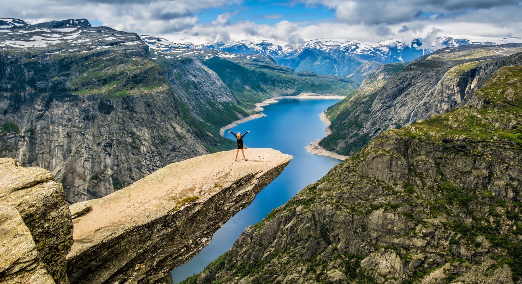
The honest grade: Blue path, Red consequences
ut.no calls the ground kupert og ulendt, undulating and rough, for most of the way. The steepest pitch is the first one, straight up from the car park, over in about five minutes. After that the difficulty is footing, not gradient: wet slabs, stone stairs with tall uneven treads, and a last stretch where a slip carries a 604-metre penalty. Stiftelsen Preikestolen, the non-profit foundation that runs the car park and maintains the trail, says budget 4 hours for the round trip.
Route data
| Detail | Information |
|---|---|
| Trailhead | Preikestolen Parking (P1), Preikestolveien 521, 4100 Jørpeland |
| Distance | 8.2 km round trip, same path out and back |
| Elevation gain | 330 m net one way; 369 m total ascent (ut.no); the foundation quotes 500 m |
| The plateau | 604 m above sea level, about 25 by 25 m, no railing |
| Time | About 4 hours; 2 to 3 hours each way for children and first-timers |
| DNT grade | Blue (middels krevende) |
| Surface | Sherpa-laid stone stairs, boardwalks over marsh, bare rock, built staircase through the Neverdalen ravine |
| Season | Open year-round. Peak June to August. Spikes when the hosts say so |
| Facilities | Toilets at the car park only. No water on the trail. Dogs on a leash. No drones |
| Emergency | 112 (rescue), 113 (medical) |
The trail, section by section
From the car park the path climbs hard for a few minutes, then eases into forest. The marshes come next, crossed dry-shod on wide wooden walkways. Sherpas from Nepal have laid stone along most of the trail to protect the ground and ease the walking, and their granite flights carry the main climb. A built staircase now replaces the loose scree of the Neverdalen ravine; it is steep, with tall treads. The final stretch runs out toward the fjord and onto the shelf. ut.no warns that the top is always much windier and colder than the car park. Stay back from the lip: 604 metres of air sit between your boots and the water.
Getting there from Stavanger
| Option | Time each way | Cost | Notes |
|---|---|---|---|
| Own car via Ryfast (Rv13) | About 40 min | Toll 143 NOK each way without AutoPASS (119 NOK Ryfylketunnelen plus 24 NOK Hundvågtunnelen), 114.40 NOK with a tag. Parking 275 NOK | Rv13 towards Røldal, exit Solbakk, Fv523 to Jørpeland. Toll both ways, rates from 21 May 2026 |
| Pulpit Rock Tours bus (Boreal) | About 50 min | 524 NOK return adult, 336 NOK child (0 to 12), 320 NOK one way | Online only. 9 daily 20 June to 13 September, fewer in spring and autumn |
| Go Fjords express bus | About 1 hour | Price shown at booking | Olav V’s gate 3, April to October, departures 08:00 to 11:00 |
| Guided day hike (Get Guided Norway) | 7 hours total | 1,390 NOK adult, 1,090 NOK child (6 to 16) | Hotel pickup, guide, about 2.5 hours on the trail. Year-round |
| Winter cruise and hike (Rødne) | 8 to 9 hours total | 2,790 NOK adult | November to April from Strandkaien at 11:00. Cruise, guide, crampons, poles, headlamp, lunch pack |
The foundation’s directions list no ferry; any guide still sending you to a Tau ferry is out of date. Toll tables are on Ferde’s Rv13 Ryfast page, bus prices on pulpitrock.no.
Parking at Preikestolen
P1, Preikestolen Parking, holds 400 cars and 20 buses at the trailhead. P2, Moslimyrå, holds 600 cars. Staff are on site 07:00 to 18:00 in summer, 09:00 to 14:00 in winter. Pay after the hike: free under 15 minutes, 40 NOK under 2 hours, 275 NOK over 2 hours, 100 NOK for motorcycles, 1,200 NOK for buses. Stiftelsen Preikestolen spends it on trail maintenance, safety and visitor management.
What to carry on this route
The foundation lists waterproofs, spare clothing, food, water, map, phone and torch. For this route, that means:
- Boots with grip and ankle support. Tall, often wet stairs.
- Waterproof shell, warm mid-layer, hat and gloves, every month. The top is always colder and windier than the car park. The layering logic is the one in our packing guide.
- Wool or synthetic base layer. No cotton.
- 1.5 litres of water and food. Nothing on the trail; BaseCamp is the only resupply.
- Headlamp and an offline map. Daylight is short from September through March, and cloud on the plateau removes the horizon.
- Spikes from late autumn to spring. Rent them at BaseCamp if you do not own a pair.
- Poles. For 369 metres of stone stairs on the way down.
Weather anchor and the turn-back rule
ut.no’s advice is blunt: if at all possible, do not walk the trail after heavy rainfall. The slabs near the edge turn slick and nothing catches a slide. Check the forecast the morning you walk and apply the Fjellvettreglene (the Norwegian Mountain Code): Rule 2, adapt the trip to ability and conditions; Rule 3, watch the weather; Rule 4, be equipped to help yourself; Rule 7, carry a map; Rule 8, turn back in time. The full code is in our Fjellvettreglene guide.
Turn-back triggers for Preikestolen, in the order you meet them:
- Heavy rain overnight or falling now. Postpone. The view is the same tomorrow.
- Wind you lean into at the car park. Stronger on top, where there is no railing.
- Cloud on the plateau. You see nothing, and the edge is harder to read.
- Ice on the stairs and no spikes. Rent them or do not go up.
- Daylight. From September to March, be off the stone stairs before dusk. Set a turnaround time at the car.
Season and winter
The trail is open year-round. Peak season is June, July and August; both bus operators run April to October. The foundation’s winter rules: spikes when the hosts tell you, no children under 5, start early and be back before dark. Fjord Norway recommends a guide in winter; the foundation says hire one if your navigation is uncertain. Unlike Trolltunga, where a guide is mandatory from October to May, nobody will stop you walking Preikestolen alone in January. That is a freedom, not a recommendation. Rødne’s guided cruise and hike runs November to April.
The crowd plan
More than 350,000 people a year means company. ut.no names the peak windows: midday, weekends, June through September. The bus loads reach the car park from about 09:00 and the plateau around 11:00. Drive, be walking by 07:30, and you share the shelf with a handful of people. Weekdays in September and early October are quieter. For the wider calendar see when to visit Norway; for what the day costs, our cost guide.
The reward: Preikestolen BaseCamp
You come off the last stair and the restaurant at Preikestolen BaseCamp is right there, inside Preikestolen Fjellstue at Preikestolveien 521: a seasonal à la carte menu of Norwegian-inspired dishes from local produce, a bar, outdoor seating and windows onto Revsvatnet lake. It operates in summer. The Fjellstue was designed by Helen & Hard, the Stavanger architects; sleep here and you walk before the buses arrive. Beside it stands Preikestolhytta, the cabin Stavanger Turistforening built in 1949, still a simple, cheaper bed. Back in Stavanger, the Preikestolen attraction page has the short version.
Questions travellers ask
How long does the Preikestolen hike take?
Budget about 4 hours for the 8.2 km round trip, the foundation’s own figure. Fit walkers finish in 2.5 to 3 hours; children and first-timers need 2 to 3 hours each way. With 40 to 50 minutes of travel from Stavanger each way, the day runs 6 to 7 hours.
How difficult is Preikestolen?
DNT grades it Blue, medium demanding, on ut.no: 330 metres of net climbing on stone stairs and rough ground, steepest in the first five minutes. In rain or ice the wet slabs and the unfenced edge push the risk above the grade, hence the foundation’s advice to avoid the trail after heavy rainfall.
How do I get to Preikestolen from Stavanger without a car?
Pulpit Rock Tours runs a direct bus in about 50 minutes for 524 NOK return, booked online in advance, up to 9 times a day from 20 June to 13 September. Go Fjords runs an express bus from April to October. Guided day hikes with hotel pickup start at 1,390 NOK per adult.
Can you hike Preikestolen in winter?
Yes. The trail stays open, but the foundation requires winter equipment and experience: spikes, warm layers, an early start, no children under 5. A guide is recommended, not required by law. Rødne’s guided cruise and hike with crampons supplied costs 2,790 NOK, November to April.
Marte Åsheim is the Mountain Safety Editor at NorgeTravel. DNT-certified guide with 18 years of experience across Jotunheimen, Rondane, and the Nordic peaks. She writes trail guides so that you come home afterward. She can be reached at hei@norgetravel.com.
Sources: ut.no (DNT) route 1111875 Preikestolen; Stiftelsen Preikestolen, preikestolen365.com (hiking, parking, how to get there, FAQ and about pages); Ferde, Rv13 Ryfast toll table valid from 21 May 2026; Pulpit Rock Tours (Boreal Travel AS), pulpitrock.no ticket categories; Go Fjords, Preikestolen Express Bus timetable; Fjord Norway listings for Preikestolen, Get Guided Norway, Lysefjorden Adventure and the restaurant at Preikestolen BaseCamp; Rødne Fjord Cruise winter programme; preikestolenbasecamp.com. Checked 11 October 2026.
规划您的挪威行程
使用我们免费的互动行程规划工具,设计您的挪威路线,预订经过验证的环保木屋和交通,并同步当地渡轮时刻表。
Up Next: Keep Exploring
盖朗厄尔峡湾RIB峡湾探险:游轮无法带您领略的风光
RIB峡湾探险带您以35节的速度,在距离七姐妹瀑布15米处飞驰。这里有关于哪些体验很棒,哪些不尽如人意,以及895挪威克朗的价格是否物有所值的所有信息。
在七姐妹瀑布下划皮划艇:在盖朗厄尔峡湾桨行4小时
盖朗厄尔皮划艇之旅让8名桨手置身于七姐妹瀑布之下,与峭壁近在咫尺。4小时,1550挪威克朗,提供干式潜水服。以下是本次体验的具体内容以及适合预订的人群。
自驾盖朗厄尔:一天之内游览老鹰之路、飞来峡谷观景台和达尔斯尼巴
老鹰之路共有11个发夹弯,海拔攀升620米。达尔斯尼巴观景台海拔1476米,盖朗厄尔峡湾在脚下犹如一条纤细的蓝色丝带。本攻略将教您如何一天内自驾游览这两处景点,轻松避开旅游大巴,不再为停车位烦恼。