赛格拉峰:塞尼亚岛峡湾村上方的山脊徒步
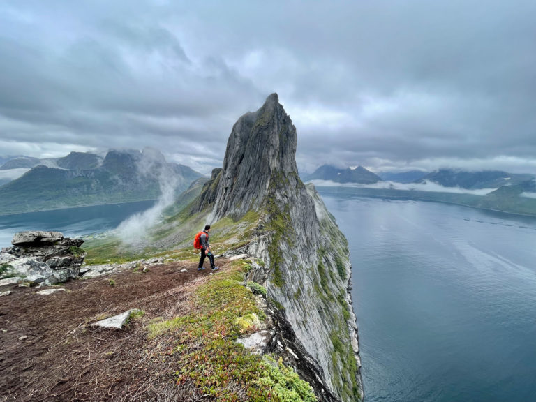
塞尼亚岛的标志性山峰。海拔639米,往返6公里,最后一段狭窄的山脊直接位于梅峡湾上方。属于挪威徒步协会(DNT)蓝色难度,末段需手脚并用攀爬。
赛格拉峰从峡湾村上方的梅峡湾拔地而起,海拔639米。往返6公里,需时4至5小时,属于挪威徒步协会(DNT)蓝色难度,最后一段需在暴露环境中手脚并用攀爬至石堆。7月份,徒步起点停车场早上8点前就已停满。请务必提早抵达,或选择9月份前来。
Segla is the peak every photograph of Senja is trying to capture. 639 metres rising out of the Mefjord, a blade of rock with a sharp profile from the west and a narrow summit ridge that makes the last 15 minutes feel alpine even though the grade on paper is DNT Blue.
The numbers are modest. The consequences of the summit scramble are not. This guide gives the route, the turn-back trigger, and what the Fjordgård trailhead looks like at 06:00 versus 10:00 in July.
The honest grade
Segla is DNT Blue on the approach. The final 100 metres is a scramble on rock with drop-offs on both sides. No fixed chains. Dry rock is straightforward for anyone comfortable with scrambling. Wet rock changes the calculation. In rain, the summit block becomes a Red-grade problem and people turn back.
If you are not used to exposure, do Hesten on the opposite side of the Mefjord first. Hesten gives you the classic Segla photograph without the scramble.
The route
Trailhead. Fjordgård village, at the head of the Mefjord on the north coast of Senja. Follow signs for the Segla parking. The car park holds roughly 80 cars and fills between 08:00 and 18:00 from late June through mid-August.
Lower section. Marked path through birch forest and open meadow. 250 metres of gain in the first 45 minutes. Boardwalks across the boggy sections.
Middle section. Above the treeline the path climbs across open slope to the base of the summit ridge. Red T-marks and cairns. 60 to 75 minutes.
Summit ridge. The last 100 metres is the hands-on section. Narrow, with exposure on both sides. Drop to the Mefjord on one side, drop to the village on the other. 15 to 20 minutes to the cairn.
Descent. Same route. Most people move slower going down the scramble. Budget 2 to 2.5 hours back.
The turn-back rule
Rain on the summit block. Wet rock is the trigger. If it starts raining during the ridge section, turn around immediately. The photograph is not worth the slip. This is Fjellvettreglene Rule 8: turn back in time, no shame in retreat.
Gear
- Proper hiking boots, not trainers. The final section has loose rock.
- Windproof layer. The ridge catches weather moving in off the Atlantic.
- Water. 1.5 litres minimum in summer.
- Map: Turkart Senja 1:50,000. Do not rely on phone only.
Fjellvettreglene applied
Rule 1: Plan. Check yr.no the night before and morning of. Rule 3: Read the weather. A forecast of showers between 12:00 and 14:00 means start at 06:00 or postpone. Rule 8: Turn back on wet rock.
Logistics
| Item | Detail |
|---|---|
| Trailhead | Fjordgård, signed Segla parking |
| Parking | ~80 cars, fee, fills by 08:00 in peak summer |
| Season | Late June to mid-October. Snow lingers in gullies until early July. |
| Nearest fuel | Botnhamn or Gryllefjord |
| Emergency | 112. Nearest hospital: Tromsø (UNN) |
Who should do Segla
Intermediate hikers comfortable with short scrambles. Anyone who does not mind a crowded trailhead. Photographers who want the ridge shot from the top rather than from across the fjord.
Who should skip it
Anyone uncomfortable on exposed rock. Families with young children — do Hesten instead. Anyone arriving on a rainy forecast: postpone rather than force it.
规划您的挪威行程
使用我们免费的互动行程规划工具,设计您的挪威路线,预订经过验证的环保木屋和交通,并同步当地渡轮时刻表。
Up Next: Keep Exploring
盖朗厄尔峡湾RIB峡湾探险:游轮无法带您领略的风光
RIB峡湾探险带您以35节的速度,在距离七姐妹瀑布15米处飞驰。这里有关于哪些体验很棒,哪些不尽如人意,以及895挪威克朗的价格是否物有所值的所有信息。
在七姐妹瀑布下划皮划艇:在盖朗厄尔峡湾桨行4小时
盖朗厄尔皮划艇之旅让8名桨手置身于七姐妹瀑布之下,与峭壁近在咫尺。4小时,1550挪威克朗,提供干式潜水服。以下是本次体验的具体内容以及适合预订的人群。
自驾盖朗厄尔:一天之内游览老鹰之路、飞来峡谷观景台和达尔斯尼巴
老鹰之路共有11个发夹弯,海拔攀升620米。达尔斯尼巴观景台海拔1476米,盖朗厄尔峡湾在脚下犹如一条纤细的蓝色丝带。本攻略将教您如何一天内自驾游览这两处景点,轻松避开旅游大巴,不再为停车位烦恼。