Skageflå:徒步探访曾躲避收税人的悬崖农场
一条红色难度级别的步道,通往盖朗厄尔峡湾上方250米、面对七姐妹瀑布的废弃农场。从中世纪一直有人居住,直到1916年。
Skageflå山地农场坐落在盖朗厄尔峡湾上方250米的悬崖岩架上。这是一条红色难度级别的步道,部分路段设有钢缆,并有暴露的悬崖小径。可乘船抵达Skagehola后攀爬45分钟,或选择陆路徒步6.5公里。这是盖朗厄尔地区最具历史意义的徒步路线。
The story I tell every client who asks about Skageflå is the one about the tax collector. When the sheriff came to collect taxes, the farmer at Skageflå removed the logs and ladders that served as the only path up the cliff face. The farm became inaccessible. The tax collector left. The farmer put the ladders back. Whether that story is fully true or partly legend, it captures what Skageflå is: a farm so vertical, so improbable, and so committed to survival that even the government could not reach it.
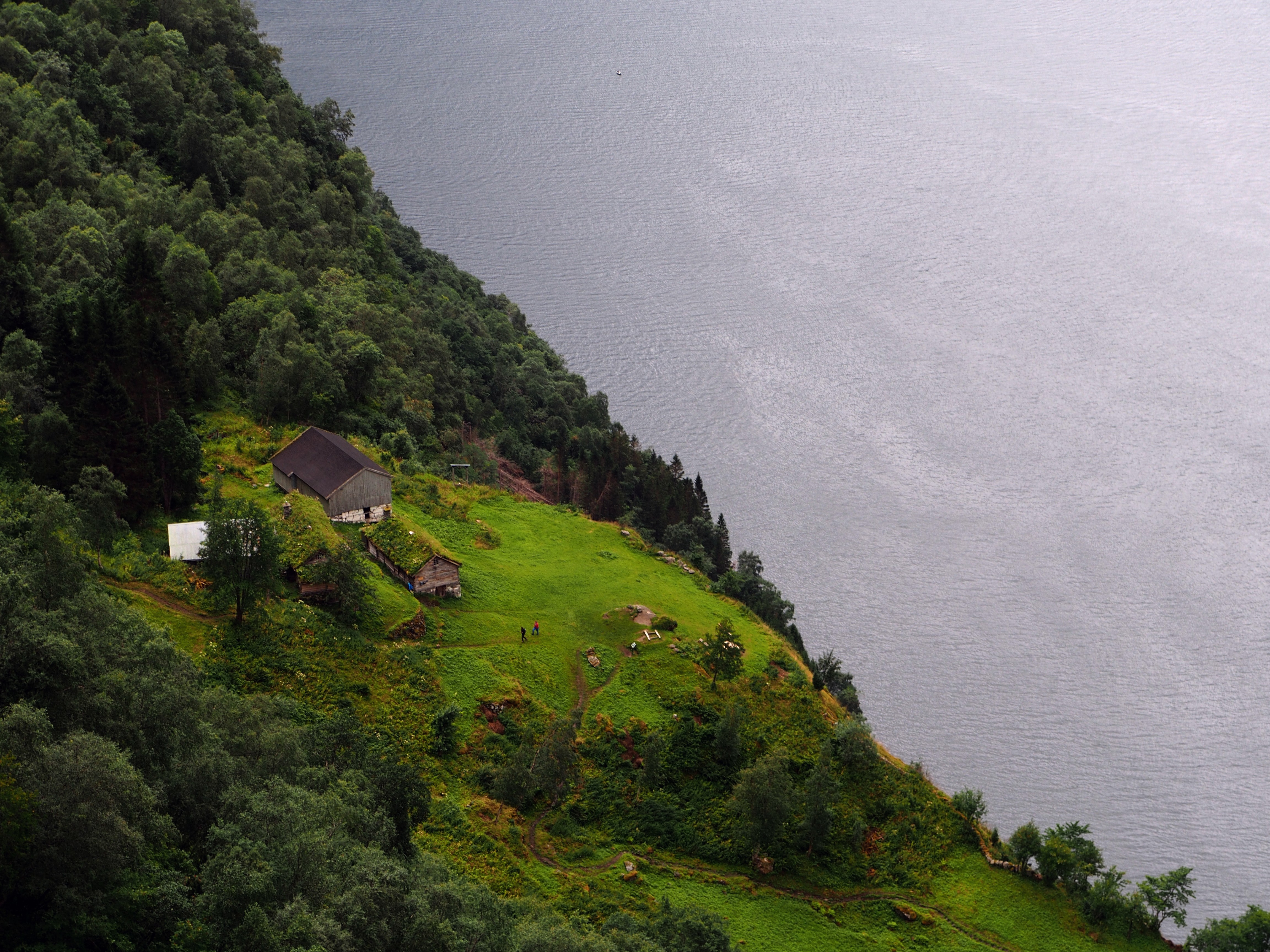
Skageflå sits on a grass ledge 250 meters above Geirangerfjord, directly facing the Seven Sisters waterfall (De Syv Søstrene) on the opposite cliff. Families farmed this ledge from the Middle Ages until 1916, when a rockslide finally made the risk unbearable. They kept 120 dairy goats, 20 to 30 sheep, 6 to 8 cows, and a horse. They tied their children to trees to stop them falling off the edge. They lowered hay and supplies by rope to boats at the fjord below. The trail to reach it today involves either a 45-minute climb from a RIB boat drop at Skagehola, or a 4-to-5-hour overland traverse from Homlong via Homlongsætra at 544 meters. Either way, you will understand why they left, and why Queen Sonja came to unveil the UNESCO plaque here in 2006.
What this trail actually is
Skageflå is graded Red (strenuous) by morotur.no, the official outdoor recreation platform for Møre og Romsdal. Red means steep sections on uneven paths, exposed passages where extra care is needed, hiking experience required, and proper footwear essential. This grade is earned. The approach from the fjord involves wire cables, ropes bolted into rock, and narrow paths clinging to the cliff face with 250-meter drops to the water. The overland route from Homlong involves sustained climbing to 544 meters before a steep descent to the farm.
You have three options to reach Skageflå, and the choice changes the day entirely.
Option 1: Boat to Skagehola, hike to farm, boat back. Take the RIB from Geiranger harbour to Skagehola, a tiny landing bay at the base of the cliff directly below Skageflå. Hike 45 minutes steeply uphill (250 meters gain over roughly 2 km) to the farm. Explore. Descend. Take the boat back. Total: 3 to 4 hours including boat transfers. This is the most efficient option and the one I recommend for most travellers.
Option 2: Boat one way, hike the other (traverse). Take the RIB to Skagehola, hike up to Skageflå, continue up to Homlongsætra (544 meters), then descend to Homlong and walk back to Geiranger. Total: 6.5 km point-to-point, 550 meters cumulative elevation, 3.5 to 4.5 hours of hiking. This is the classic route and shows you the full range of the trail: cliff face, farm ledge, mountain pasture, and fjord-side road.
Option 3: Full overland round trip from Homlong. Park at Homlong (2 km from Geiranger), hike up to Homlongsætra (544 meters), descend to Skageflå (250 meters), and retrace the route back. Total: 8.5 to 9 km, 850 meters cumulative elevation, 4.5 to 5.5 hours. This is the option for experienced hikers who want the full day without booking boat transport.
What works
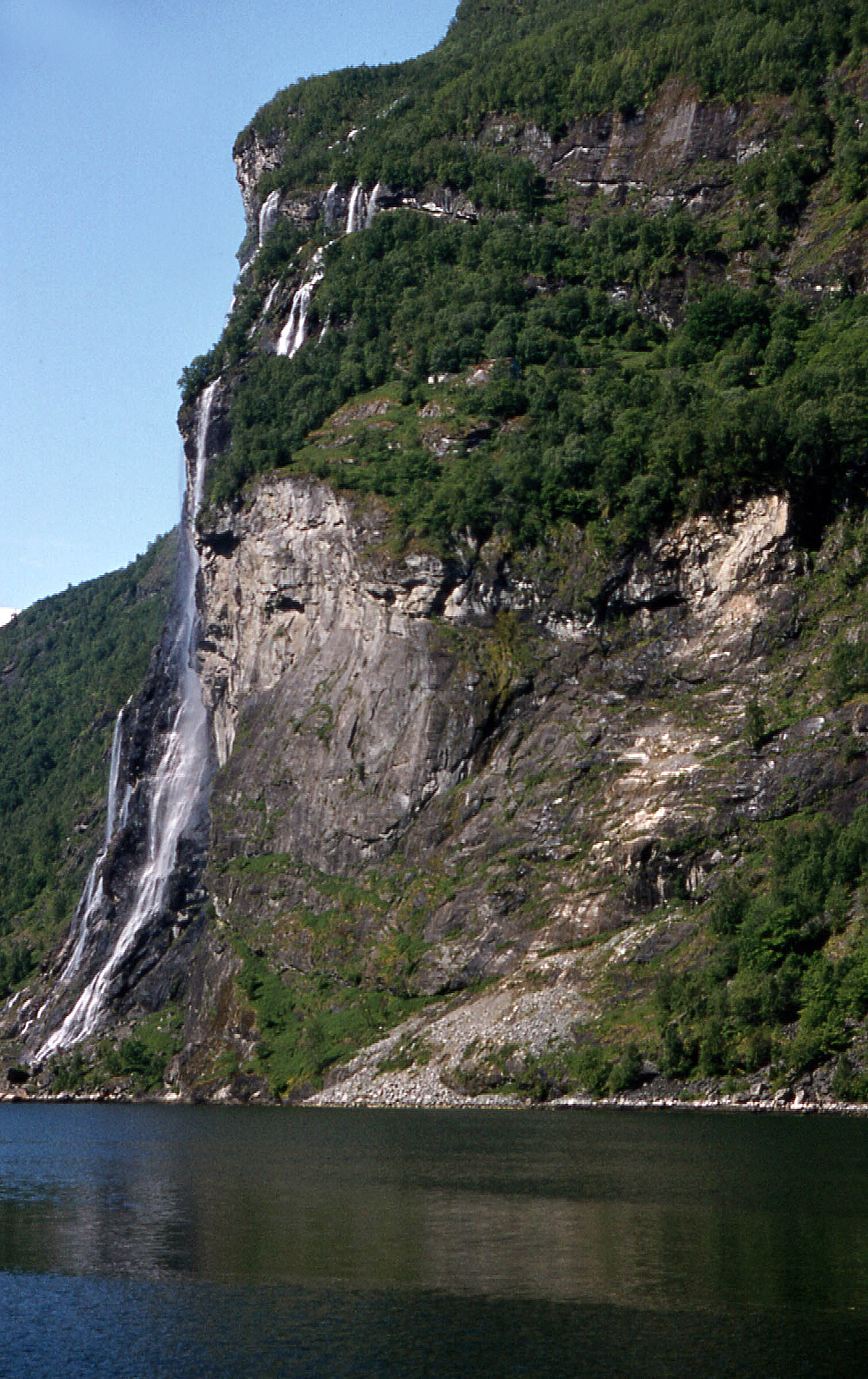
- The view from the farm. You stand on a grass ledge 250 meters above the fjord with the Seven Sisters waterfall cascading directly opposite. The abandoned Knivsflå farm is visible on the cliff near the waterfall. The fjord stretches in both directions below. From May to July, when snowmelt feeds the Seven Sisters at full volume, this is the finest frontal view of the waterfall on Geirangerfjord.
- The history in the landscape. The restored farm buildings are original. You can see the grass plateau where 120 goats grazed. You can see the cliff edge where children were tied to trees. You can see the rock face where ladders once provided the only access before the trail was improved. This is not a museum reconstruction. It is the actual place where families survived for centuries on a ledge that most modern hikers approach with wire cables and racing hearts.
- The boat approach. The RIB ride from Geiranger to Skagehola passes the Seven Sisters, the Bridal Veil (Bruresløret), and the Suitor (Friaren) waterfalls. It is a mini fjord safari before the hike even begins. The operator (Fjord Guiding) runs departures every hour from 09:00 to 19:00 in summer.
- The UNESCO connection. Skageflå is specifically cited in the UNESCO World Heritage designation for the Geirangerfjord. Queen Sonja unveiled the heritage plaque at the farm in 2006. The cliff farms are not a footnote to the fjord’s status. They are a primary reason for it.
What does not work
- The exposure from Skagehola. The climb from the boat landing to the farm is steep, narrow, and exposed. Wire cables and ropes bolted into rock provide handholds, but the path clings to the cliff face with drops of 250 meters to the fjord below. If you have a fear of heights, this approach will be genuinely difficult. The overland route from Homlong avoids the cliff face but adds significant elevation and distance.
- Not suitable for children. The official trail description and FJORDS.COM both state this trail is not suitable for children. The exposed cliff sections, wire cables, and drop-offs are too dangerous for young hikers regardless of their fitness.
- The rockslide risk. Skageflå was abandoned in 1916 because of rockslide danger. That geological reality has not changed. The Åkerneset rock formation on the opposite side of the fjord is continuously monitored for a potential catastrophic collapse. This is not a reason to skip the hike, but it is a reality that the Norwegian authorities track with real-time sensors. The trail is open because the current risk is assessed as manageable, not because the risk is zero.
- No services on the trail. There is a water tap and an outhouse at the farm, but no cafe, no shop, and no shelter beyond the farm buildings. Bring water, food, and rain gear. Weather changes in the fjord within an hour.
The honest assessment
Skageflå is the hike that explains why Geirangerfjord is a UNESCO World Heritage site. The fjord is not just geology. It is the human story of families who farmed vertical terrain for centuries because the flat land was already taken. The trail is graded Red for good reason: the cliff exposure is real, the wire cables are there because you need them, and the elevation changes are sustained. But the payoff is standing on the same ledge where a farmer once hid from the tax collector, looking directly at the Seven Sisters waterfall from 250 meters above the water, and understanding what the UNESCO designation actually protects.
If you take the boat option, the total time commitment is 3 to 4 hours including transport. If you do the overland traverse, budget a full day. Either way, Skageflå delivers the most historically significant and physically demanding experience in the Geiranger area. It is not for everyone. It does not try to be.
The logistics
| Detail | Information |
|---|---|
| Trail grade | Red (strenuous) — morotur.no official grading |
| From Skagehola (boat) | ~2 km, 250 m elevation, 45 min up |
| Traverse (Skagehola to Geiranger) | 6.5 km, 550 m cumulative, 3.5–4.5 hrs |
| Round trip from Homlong | 8.5–9 km, 850 m cumulative, 4.5–5.5 hrs |
| Farm elevation | 250 m above Geirangerfjord |
| Season | Late May to September (boat: mid-April to mid-September) |
| Trail fee | Free (boat transport separate) |
| RIB boat (one way) | 249 NOK per person (Fjord Guiding, every hour 09:00–19:00) |
| Guided hike | 4,500 NOK (1–5 people), 6,500 NOK (6–8 people), incl. boat + guide |
| Parking (Homlong) | 50–120 NOK, 2 km from Geiranger |
| Farm GPS | 62.1101°N, 7.1212°E |
| Boat operator | Fjord Guiding (skagefla.no) — +47 478 020 10 |
| Emergency | 112 (police/rescue) or 113 (medical) |
Trail safety
Skageflå is graded Red (strenuous) by the official Møre og Romsdal outdoor platform. The Fjellvettreglene (Mountain Code) is not optional on this trail. Four rules are directly relevant:
- Rule 1: Plan your route and inform someone. The traverse involves a boat one way and a hike the other. Know which direction you are going before you start, and tell someone your plan and expected return time.
- Rule 2: Adapt the trip to ability and conditions. Wire cables and exposed cliff paths require steady nerves, grip strength, and hiking boots. If the Skagehola approach exceeds your comfort level, the overland route from Homlong avoids the cliff face but demands more fitness.
- Rule 4: Be equipped to help yourself and others. No shelter, no services, no mobile coverage guarantee above the farm. Bring water, food, rain gear, and a first aid kit. The farm has a water tap and an outhouse, but nothing else.
- Rule 8: Turn back in time. If weather deteriorates on the traverse, the descent from Homlongsætra to Skageflå becomes slippery and exposed. Better to retrace to Homlong than push on to the cliff face in rain.
Who should hike this
- Experienced hikers comfortable with exposure. If you have done Besseggen, Kjerag, or Preikestolen, you have the fitness and nerve for Skageflå. The exposure from Skagehola is comparable to the steepest sections of those trails.
- History-focused travellers. Skageflå is the most historically significant site on Geirangerfjord. The cliff farm, the UNESCO designation, and the Seven Sisters waterfall opposite make this the single most culturally rich hike in the area. The Norsk Fjordsenter in Geiranger provides excellent context; visit it before the hike.
- Travellers taking the boat option with limited time. The RIB to Skagehola, hike up, explore, hike down, RIB back: 3 to 4 hours total. This fits into a half-day, leaves time for the Fossevandring or Eagle Road, and delivers the most demanding Geiranger experience in the shortest window.
Who should skip this
- Anyone with a fear of heights. The Skagehola approach involves 250 meters of cliff face with wire cables and narrow paths above the fjord. The overland route from Homlong is less exposed but still includes steep descents with drop-offs. If vertigo is an issue, Storseterfossen and Løsta from Vesteras are better alternatives.
- Families with children. The trail is officially described as not suitable for children. The exposed cliff sections, wire cables, and unprotected edges are too dangerous for young hikers.
- Travellers in poor weather. Rain makes the rock surfaces, wire cables, and cliff paths slippery and dangerous. Fog removes visibility on exposed sections. If the forecast shows rain or thunderstorms, postpone. The trail will be here when the weather clears.
Ingrid Solheim is the Fjord Logistics Editor at NorgeTravel. She spent eleven years putting tourists into rental cars in Bergen and watching them drive off with itineraries that were never going to work. Her guides are written so that does not happen to you. She can be reached at hei@norgetravel.com.
Images: Skageflå farm by rheins (CC BY 3.0, Wikimedia Commons). Seven Sisters waterfall by W. Bulach (CC BY-SA 4.0, Wikimedia Commons).
规划您的挪威行程
使用我们免费的互动行程规划工具,设计您的挪威路线,预订经过验证的环保木屋和交通,并同步当地渡轮时刻表。
Up Next: Keep Exploring
盖朗厄尔峡湾RIB峡湾探险:游轮无法带您领略的风光
RIB峡湾探险带您以35节的速度,在距离七姐妹瀑布15米处飞驰。这里有关于哪些体验很棒,哪些不尽如人意,以及895挪威克朗的价格是否物有所值的所有信息。
在七姐妹瀑布下划皮划艇:在盖朗厄尔峡湾桨行4小时
盖朗厄尔皮划艇之旅让8名桨手置身于七姐妹瀑布之下,与峭壁近在咫尺。4小时,1550挪威克朗,提供干式潜水服。以下是本次体验的具体内容以及适合预订的人群。
自驾盖朗厄尔:一天之内游览老鹰之路、飞来峡谷观景台和达尔斯尼巴
老鹰之路共有11个发夹弯,海拔攀升620米。达尔斯尼巴观景台海拔1476米,盖朗厄尔峡湾在脚下犹如一条纤细的蓝色丝带。本攻略将教您如何一天内自驾游览这两处景点,轻松避开旅游大巴,不再为停车位烦恼。